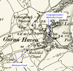
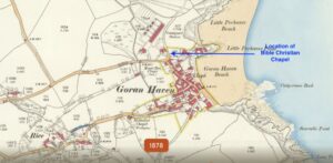
This profile of Lanner Bible Christiam Chapel has been compiled by Jo Lewis and Tony Mansell. Located on Lanner Hill, the Chapel and school room are set back from the main road through Lanner. Heritage Gateway: Bible Christian chapel and attached Sunday school, built in 1866, now all used as village hall. Local rubble with…Continue Reading “Mapping Methodism – Lanner Bible Christian Chapel”
Map: https://maps.nls.uk/geo/explore/side-by-side/#zoom=10.4&lat=52.44811&lon=-3.07812&layers=6&right=ESRIWorld This profile of Porthleven Wesleyan Chapel has been compiled by Jo Lewis and Tony Mansell. 1790 Wesleyan Chapel Located in Loe Bar Road Methodist Chapel, Mounts Road at the westerly end of current houses on Mounts Road. The building still exists (The Old Chapel) with a date plaque (1790-1820) Heritage Gateway: The…Continue Reading “Mapping Methodism – Porthleven Wesleyan Chapel”
Map: https://maps.nls.uk/geo/explore/side-by-side/#zoom=10.4&lat=52.44811&lon=-3.07812&layers=6&right=ESRIWorld This profile of Kestle Mill Wesleyan Chapel has been compiled by Jo Lewis and Tony Mansell. Located at the south-west corner of the minor junction in the village, at the ‘Trerice Turn’ bus stop and north-west of Summercourt along the A3058. Heritage Gateway: A new chapel for the parish of Newlyn East, seating…Continue Reading “Mapping Methodism – Kestle Mill Wesleyan Chapel”
Map: https://maps.nls.uk/geo/explore/side-by-side/#zoom=15.5&lat=50.20331&lon=-5.23820&layers=6&right=ESRIWorld This profile of Four Lanes UMFC has been compiled by Jo Lewis and Tony Masell. Heritage Gateway: A United, later the Free United, Methodist chapel is recorded at this location in Four Lanes on the 1st and 2nd edition 1:2500 1880 and 1907 OS Maps. By 1907 a separate Sunday school had been…Continue Reading “Mapping Methodism – Four Lanes United Methodist Free Church”
Map:https://map.cornwall.gov.uk/website/ccmap/?zoomlevel=9&xcoord=156707&ycoord=37840&wsName=ccmap&layerName=Buildings,%20Sites%20and%20Monuments%20-%20points This profile of Copperhouse Wesleyan Chapel has been compiled by Jo Lewis and Tony Mansell. Wesley preached at ‘the Hayle’ in 1765. The Cornish Copper Company were building residential properties in Copperhouse by 1779, including some along what had been the Bodriggy foreshore, which were built from Scoria (slag from the copper smelting…Continue Reading “Mapping Methodism – Copperhouse Wesleyan Chapel”
Map: https://maps.nls.uk/geo/explore/side-by-side/#zoom=17.1&lat=50.23977&lon=-5.18294&layers=6&right=ESRIWorld This profile of St Day Primitive Methodist Chapel has been compiled by Jo Lewis and Tony Mansell. 1828 Primitive Methodist Chapel Built in 1828 on the site of an earlier single storied thatched Baptist chapel (built in 1803) which was the only place of worship in the village until that year…Continue Reading “Mapping Methodism – St Day Primitive Chapel”