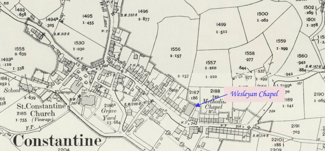
Mylor Bridge is a village in Mylor civil parish at the head of Mylor Creek, about five miles north of Falmouth. This profile of Mylor Primitive / Bible Christian Chapel has been compiled by Jo Lewis and Tony Mansell.   Heading briefly up Passage Hill, you can find this old chapel on the right. Early…Continue Reading “Mapping Methodism – Mylor Bridge Primitive Methodist / Bible Christian Chapel”

Perranwell is a little to the north of Perranarworthal. It has a railway station on the Maritime Line between Truro and Falmouth Docks. This profile of Perranwell Bible Christian Chapel has been compiled by Jo Lewis and Tony Mansell.   The site of a “Bible Christian Chapel” with a possible Sunday school is recorded on…Continue Reading “Mapping Methodism – Perranwell (Chyvogue) Bible Christian Chapel (Perranarworthal)”

Godolphin Cross is a village in the civil parish of Breage, midway between the towns of Hayle and Helston. This profile of Godolphin Cross / Herland Cross Bible Christian Chapel has been compiled by Jo Lewis and Tony Mansell.   Bible Christian, later Methodist chapel. Original 1844 chapel converted to schoolroom when new chapel added…Continue Reading “Mapping Methodism – Godolphin Cross / Herland Cross Bible Christian Chapel”

Quenchwell is a short distance north of Carnon Downs. This profile of the Quenchwell (Chycowling) first Bible Christian Chapel has been compiled by Jo Lewis and Tony Mansell.   A Bible Christian chapel is recorded at this location in Chycowling on the 1st Edition 1:2500 1880 OS Map. By 1907 a new chapel 138037 had…Continue Reading “Mapping Methodism – Quenchwell (Chycowling) first Bible Christian Chapel”

Ebenezer, Valley Lane, Carnon Downs is an isolated location a short distance north of Canon Downs and west of Quenchwell. This profile of Carnon Downs (Ebenezer) Chapel has been compiled by Jo Lewis.   From The centre of the village, take Manse road north to Valley Lane, following this road until it becomes a track….Continue Reading “Mapping Methodism – Carnon Downs (Ebenezer) Chapel”

Geor or Gear is located on a minor road between Burncoose and Stithians. This profile of Burncoose Wesleyan Chapel has been compiled by Jo Lewis and Tony Mansell.   From Comford, follow the A393 south taking a right turn just before Burncoose, and then follow the road to take a left (Signposted Stithians). Follow the…Continue Reading “Mapping Methodism – Geor or Gear Wesleyan Chapel”