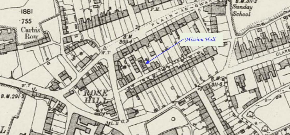
King Street is in the western part of Reduth. This profile of Mission Hall – King Street Chapel or Mr Wilson’s chapel has been compiled by Jo Lewis and Tony Mansell. The Mission Hall was possibly related to Methodism but its work was available to all. Located in King Street, near the junction with…Continue Reading “Mapping Methodism – Mission Hall – King Street Chapel, Redruth (Mr Wilson’s chapel)”
Pengegon is an area within Camborne – from Beacon Fore Street into Meneth Road and following the road to Pengegon. This profile of Pengegon Wesleyan Chapel has been compiled by Jo Lewis and Tony Mansell. 1799: Pengegon Methodist society existed – recorded in a circuit preachers book. The 1st and 2nd Edition 1:2500 1880…Continue Reading “Mapping Methodism – Pengegon Wesleyan Chapel”
Lowertown-by-Helston is a large hamlet in Sithney civil parish, bordering Wendron parish, in Cornwall, United Kingdom. The hamlet is one mile north of the centre of the town of Helston and is built around the River Cober. This profile of Lowertown Wesleyan Chapel has been compiled by Jo Lewis and Tony Mansell. Continue north…Continue Reading “Mapping Methodism – Lowertown Wesleyan Chapel (Tregannock / Anvower / Gwavas Hill)”
Lowertown-by-Helston is a large hamlet in Sithney civil parish, bordering Wendron parish, in Cornwall, United Kingdom. The hamlet is one mile north of the centre of the town of Helston and is built around the River Cober. This profile of Lowertown / Lowertown Higher United Methodist Free Church has been compiled by Jo Lewis and…Continue Reading “Mapping Methodism – Lowertown / Lowertown Higher United Methodist Free Church (Tuckingmill / Anvower)”
Burras is a village in west Cornwall, east of Black Rock and approximately five miles south of Redruth on the B3297 road. This profile of Burras Wesleyan Chapel has been compiled by Jo Lewis and Tony Mansell. Located just off the road next to the Cober river in its own parcel of land. An…Continue Reading “Mapping Methodism – Burras / Burhos Wesleyan Chapel”
Burras is a village in west Cornwall, east of Black Rock and approximately five miles south of Redruth on the B3297 road. This profile of Burras UMFC has been compiled by Jo Lewis and Tony Mansell. United Methodist chapel is recorded on the 2nd Edition 1:2500 OS map. The chapel is in the stuccoed…Continue Reading “Mapping Methodism – Burras / Burhos United Methodist Chapel”


