

Stithians, also known as St Stythians, is a village in the middle of the triangle bounded by Redruth, Helston and Falmouth. Foundry is an area within Stithians. This profile of Foundry United Methodist Free Chapel has been compiled by Jo Lewis and Tony Mansell.
John Welsey visited Stithians in 1744-50 and brought Methodism to the parish.
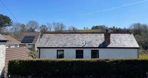
From Ponsanooth, head north and take the left turn to Stithians, finding your way to Foundry Road via Tubbon Hill. The United Methodist Chapel is to the left (south) of the road, slightly set back on this site of a house, behind the parking area. It is marked on 1880 -1930 maps, and still a building but not marked as a chapel by the 1960s.
Non-Conformist. There were Wesleyan and Free Methodist chapels in this parish. (Genuki)
The 1st and 2nd Edition 1:2500 1880 and 1907 OS Maps record a United, later a Free United, Methodist chapel at this location in Foundry, Stithians. The building is still extant but shown on the current Mastermap as a dwelling ‘The Barn’. (Cornwall Council Heritage Gateway)
 (Photo: Jo Lewis)
Build date unknown.
1880: Appears on old.maps.co.uk.
1907: The Methodist New Connexion, Bible Christians and United Methodist Free Churches amalgamated to become the United Methodist Church.
1907: Became a United Methodist Chapel.
1938: Appears on old.maps.co.uk.
1972: Negatives, Stithians Foundry Chapel. (Kresen Kernow X540/30
Converted to dwelling.