
Mapping Methodism – Allet United Methodist Free Church
Categories Mapping Methodism, Projects1 Comment
Allet is a hamlet one mile west of Shortlanesend on the B3284 Truro road. It can be found south of the A30, north of the Shortlanesend road. The chapel is easily found by turning onto the B3284 from the A30 at the Wind farm. The Chapel which is now the Methodist Church is on the left. This profile of Allet United Methodist Free Church has been compiled by Jo Lewis and Tony Mansell.
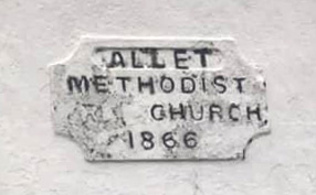
A wayside chapel (recorded as a United on the 1st Edition 6″ OS map c1880, United Free on the 2nd Edition 6″ OS map c1907). Small stuccoed example with moulded gable coping facing the road and central round-arched window with margin panes, otherwise horned sashes. Parallel group with formerly detached Sunday school q.v. of 1866. (Cornwall Council Heritage Gateway)
Built as a United Methodist Free Church.
1866: Build date. (SWChurches)
The Chapel was built as a United Methodist Free Church in 1866. The Sunday school next door was built much later in 1961 but matches it well.
 (Photo: Barry West)
1902: “Allet U.M.F.C. Chapel was re-opened last Friday after being closed three weeks tor renovation which has been creditably done by Mr. Jollief, Truro…” (Royal Cornwall Gazette – Thursday 07 August 1902)
1904: Allet United Methodist Sunday School: “… On Monday afternoon the Sunday school, with the teachers, formed into procession and headed by Queens Brass Band, paraded Allet and marched to the field for tea and buns.” (30 June 1904 – Royal Cornwall Gazette)
1907: Allet U M F Church: “… On Monday afternoon the annual tea treat was held in Mr. Northey’s field in delightful weather, and the Indian Queens Brass Band discoursed music throughout the afternoon and evening.” (4 July 1907 – Royal Cornwall Gazette)
Part of Truro United Methodist Free Churches Circuit until 1907. (SWChurches)
1907: The Methodist New Connexion, Bible Christians and United Methodist Free Churches amalgamated to become the United Methodist Church.
1907 to 1932: Known as Allet United Methodist Church between. (SWChurches)
1907 to 1932: Part of St George’s United Methodist Circuit. (SWChurches)
1932: The Wesleyan, Primitive Methodist and the United Methodist Church amalgamated to become the Methodist Church of Great Britain.
1932: Became Allet Methodist Church. (SWChurches)
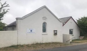 Allet Methodist Chapel (Photo: Barry West)
 Allet Methodist Chapel (Photo: Barry West)
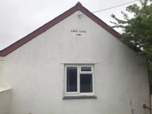 Allet Methodist Sunday School (Photo: Barry West)
A dear little wayside Bethel. Does Allet umc have any monogrammed china, maybe an ” odd” saucer or anything about?