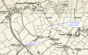
Mapping Methodism – Troon Wesleyan Chapel

The location of the chapel on 1888 map Troon is a large village, 1.5 miles south-east of Camborne This profile of Troon Wesleyan Chapel has been compiled by Suzanne Trythall   The earliest mention of places of worship in and around Troon indicate there were seven meeting houses, including Stennack and Copper Hill. A chapel…Continue Reading “Mapping Methodism – Troon Wesleyan Chapel”

Mapping Methodism – Helston Bible Christian Chapel (Meneage Street)

Helston is a town at the northern end of the Lizard Peninsula approximately 12 miles (19 km) east of Penzance and 9 miles (14 km) south-west of Falmouth. This profile of Helston Bible Christian Chapel (Meneage Street) has been compiled by Betty Pascoe.                            

Mapping Methodism – St Ives Teetotal/New Connexion (Now known as The Drill Hall)

This profile of St Ives Teetotal/New Connexion Chapel , Chapel Street, St Ives, has been compiled by Val Thomas of St Ives Old Cornwall Society.   1743: A 120 strong Methodist Society formed in St Ives. 1743: First visit by Charles Wesley. August 1743: John Wesley visited St Ives. 1745: John Wesley preached in Street…Continue Reading “Mapping Methodism – St Ives Teetotal/New Connexion (Now known as The Drill Hall)”

Mapping Methodism – Troon (Chapel Square) United Methodist Free Chapel

Location of chapel on 1888 map Troon is a large village, 1.5 miles south-east of Camborne. This profile of Troon (Chapel Square) United Methodist Free Chapel has been compiled by Suzanne Trythall.   1871: a breakaway group of Wesleyan Reformers (meeting in the original Wesleyan Chapel) obtained land from the Fortescue of Bodmin estate on…Continue Reading “Mapping Methodism – Troon (Chapel Square) United Methodist Free Chapel”

Deveral is a hamlet in the parish of Gwinear-Gwithian (1908 OS 1:2,500 map extract). This profile of Deveral Wesleyan Chapel has been compiled by Guy Channer. 1840 Tithe Map extract indicating a building on the site of Deveral Chapel Deveral Chapel in 1966 shortly after last external redecoration as a working chapel (Photo: Cedric Appleby)…Continue Reading “Mapping Methodism – Deveral Wesleyan Chapel”

Plantation is a small hamlet situated near Troon, Camborne. The chapel was called ‘Plantation’ because it was built in a wooded area owned by the St Aubyn family. This profile of Plantation Wesleyan Chapel has been compiled by Suzanne Trythall   Lead map shows the location of first chapel on 1888 map   1832: the…Continue Reading “Mapping Methodism – Plantation Wesleyan Chapel”