
By Tony Mansell
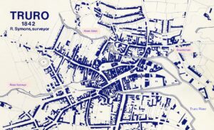
No story of Truro could be told without reference to its rivers and their role in its development. Sailing ships and then steam ships were a common sight as they made their way from Falmouth Haven, along what we now know as Carrick Roads, the River Fal and into Truro River before discharging their goods or continuing their journey up the inner-city rivers. It’s not difficult to imagine children of that period collecting ships’ names as eagerly as those of a later age jotting down railway engine numbers.
Before Cornwall’s roads were made more usable, it’s waterways were the preferred means of transportation and inland ports like Truro, Tregony and Lostwithiel flourished. Gradually though, with improved roads and the growth of the railway, the rivers’ commercial importance reduced. Despite that however, they remain an important means of transport for goods to and from the city.
Truro’s relative safety from mauruding pirates also made it attractive compared to Cornwall’s sea ports but this confidence was badly shaken in 1349 when pirates made their way up the river and ransacked parts of the town.
The growth of Falmouth as a trading port following the ‘English Civil War’ reduced the need to travel up the lengthy river. It was also possible to avoid the twists and turns of the narrow channel through the mudbanks of the Truro River – the vast areas of mud now restricts its use and presents a less than attractive approach to the city but no doubt the wading birds would disagree with this viewpoint.
From time to time there were suggestions as to how the channels could be widened and kept free of mud. There was an abortive attempt to use the mud to make bricks and perhaps a trick was missed when an offer to buy the sticky material was refused as being less than the required figure. Dredging seems to be the only answer but it would now be a huge and costly task.
Truro has long wrestled with being situated in a bowl-shaped valley with rivers running into it carrying with them soil from the fields and mines which clogged its arteries. Much of the time the relentless passage of fast-flowing waters flushed the channels as they made their way through the city and into the Truro River but it was a fight against the forces of nature and for many years it was a losing battle.
Truro was no different to so many other places in permitting its inner-city rivers to be used as sewers and allowing its waters to be taken and returned by businesses after it had been used for often unsavoury purposes. This was in less well-informed times and before mankind had the will, the technical ability or the funds to obviate it. The result was silting rivers and severe flooding in many parts of the town/city when storm water met high tides. A series of sluice gates for flushing were installed but their use was a hit-and-miss affair and either there was an insufficient flow or the gates failed to be used as this newspaper letter shows:
“We have noticed with extreme regret for many months past, and even during the very hot weather we had in June and July, that the sluice at Lemon-street bridge was never once used. We feel assured that if this were properly attended to the health and comfort of the inhabitants of that part of the town would be much benefited and enhanced. It should be remembered that the Lemon-bridge sluice is capable of damming back about 350,000 gallons of water twice a day, and the sluice near Victoria-place 170,000 gallons. If these two sluices are let go at proper stages of the tide, seven or eight times every week, the bed of the river would be scoured and cleaned to a very great extent. Why, also, should not arrangements be made for scouring the eastern channel by the river Allen? The water is dammed back at Mr Orchard’s mills, and surely that gentleman, himself an active member of the Town Council, would offer every facility in his power for promoting the health of the town.” (1) (West Briton August 1873)
There was also one occasion when the timing of the release of water was so mis-judged that a ‘tidal surge’ swept all before it.
A few instances of flooding is mentioned throughout this article but the occurences were frequent and some within living memory.
Whilst the rivers presented a continual threat however, they provided huge opportunities: for trade, commerce and leisure, and Truro would be a much poorer place without them.
The movement of water provided the power to drive waterwheels and to operate all sorts of mechanical apparatus. Mills (grist, wool, paper) lined Truro’s rivers and helped build the town into a commercial centre and with that came the provision of jobs and the ability to ‘turn a shilling’.
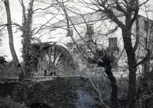 Scawswater Mill on the River Allen
Timber was imported from Canada, Scandinavia, Russia and elsewhere and in the second half of the 20th century, Garras Wharf was a large complex from where Harvey & Co supplied the local construction industry. Quays and wharves were constructed and timber pounds formed where the imported logs were stored for eventual use.
An ever-increasing demand for coal to power the mines, the factories, the gas works and for domestic needs meant regular deliveries from Wales to Newham.
Truro, being a Stannary town, tin was brought from the mines to the port to be assayed at the Coinage Hall before being exported. The assaying was undertaken so that the ‘King’ could have his (considerable) share of the value of the hard-won mineral. Despite this law however, some found its way abroad by other routes that didn’t involve the Coinage Hall!
Copper ore was brought here and shipped to South Wales for smelting as the process required considerably more coal than copper and it was cheaper to take the metal to coal rather than the other way around.
The needs of the developing town were extensive, far more varied than the examples included here, and even the arrival of boats carrying bananas was not unusual.
As leisure time expanded, the attraction of pleasure boats increased and good business was to be done by some enterprising families. This should not surprise anyone considering the beauty of the River Fal and its tributaries.
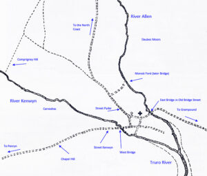 An outline of the inner-city rivers
In ‘The Book of Truro,’ H L Douch comments on the possible derivation of Truro’s name suggesting that ‘Tri-veru,’ ‘Try-weru,’ ‘Trywru’ or ‘Tryurw’ was the Cornish equivalent of the English, ‘Three Rivers’. There are others however, who feel that the name relates to the city’s three main entry streets and even one respected linguist who believes that it has nothing to do with the number three at all. Leaving that aside, we are going to concentrate here on the rivers, a complicated enough subject as it is.
So, if it is three rivers then which are the contenders? The Allen and Kenwyn are a given in which case we are simply searching for the third but here again there is a disparity of opinions. Some claim that the third river is the Truro River itself while others plump for a little known ancient stream emanating from an area known as Glasteinan after which the river may be named.
River Allen
The River Allen (Dowr Alen) may have been so-named because it flows through the Parish of St Allen but whether the river took its name from the parish or the other way around we do not know.
The river is fed by two spurs which journey many miles from the north and the north-west before combining and travelling through Idless. It once powered the mighty Scawswater Mill just downstrean from Idless and then fed a leat which provided a sufficient flow to turn the Moresk or Duchy Mill waterwheel. The river meanders across the delightful Daubez Moors and enters the city in the shadow of Truro Viaduct before reaching Moresk, an area where the road names and layout have changed considerably across the years.
The River Allen within Truro
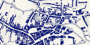 Exploded view of R Symons’ map showing the line of the River Allen as it passes through Truro
(47) Moresk Ford/Bridge (37) Mill Pool (36) The Pool Mills (35) Old Bridge Street (50) St Clement Street (34) New Bridge Street (51) St Austell Street (30) Boscawen Street – included to aid location (25) Eny’s Quay (3) The Glasteinan River (24) Town Quay
Heading relentlessly on, the river passes under the 1881 Moresk Bridge (2) (formerly a ford), and into the urbanised area where it had once had the much older name of Magna Aqua de Treveru Bigham: the Great Water of Little Truro.
Moresk is now linked to Pydar Street by St Clement Street but the route which preceeded this revised layout was Goody Lane, later Good Wives Lane, and it was at the Moresk end of this lane, in the mid-1800s, that a house was swept away by flood waters. (3) Acton 1 The damage was extensive and even East Bridge was damaged during the winter of 1848/49. (4)
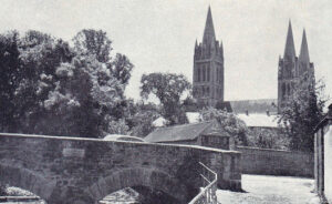 The 1881 Moresk Bridge
The river runs along the left of St Clement Street and then turns right and crosses under it to emerge and make its way through the medieval Mill Pool. (5) Here, a set of sluice gates were installed to control the flow of water.
The Mill Pool had many uses: to power the waterwheel of a medieval corn mill (possible other types of mills as well), wool was washed here, I believe the Baptists and Mormans used the waters here and at Daubez Moor for baptisms and even elephants from visiting circuses were brought here to be washed.
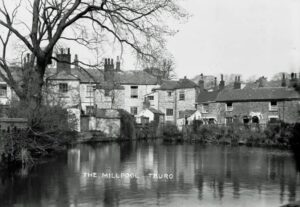 The Mill Pool
Built over the river here is an 1887 pump house as part of the works of Truro Cathedral. It is a single room brick built structure which later became known as ‘Tardis House’ and its uses have included as a gents’ urinal, a police office and latterly as an office and exhibition space. (6)
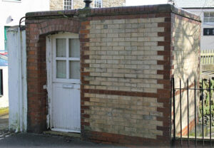 The ‘Tardis’
From the Mill Pool, the Allen travels under the 1836 St Mary’s Sunday school and East Bridge or St Clement’s Bridge (7) in Old Bridge Street.
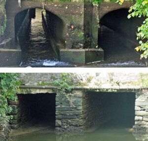 East Bridge or St Clements Bridge: top image is from up-river and the lower one is from down-river
Old Bridge Street is very ancient and very prone to flood such that the customers of the many hostelries there were often described as needing webbed feet. The street was once very important as it was the main vehicular entrance to the town from the north. It was busy with public houses and many businesses including a bakery and an engineering works operated by members of my family in the 19th/20th century. Quite large boats were able to navigate to the bridge and the quay just below seems to have been a particularly good unloading place.
By the mid-1700s there were concerns at the number of vehicle/pedestrian accidents in Old Bridge Street and the planners turned their attention to a location a short way down river. For this to be used however, another bridge over the river had to be built. This was duly completed in the early 1770s and replaced the ford known as ‘The Steppings’. It aquired the appropriate name of ‘New Bridge’ (8) and the street became ‘New Bridge Street’. Unfortunately for those further upstream, the bridge restricted the headroom and limited the type of boats which could use the quays further up river. On the plus side, the street provided an improved vehicular entrance into the town although it is little wider than Old Bridge Street.
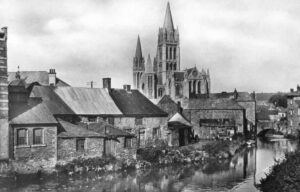 Post-1910 with the 1770s New Bridge to the right
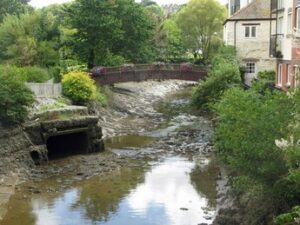 Just a little down river is a modern footbridge designed by Truro architect, John Crowther (2010 Photo: Tony Mansell)
Next, we come to Furniss Island (9) which is now a public green space but was once the location of at least three quays for local businesses including the Furniss biscuits and confectionery company established in 1875.
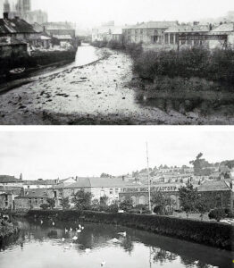 Furniss Island from Boscawen Bridge
By the mid 19th century, New Bridge Street had outlived its purpose as the main road from the north and the decision was taken to provide a more direct and improved entry. Once again there were concerns regarding height restrictions but in 1849 a timber bridge was built linking the Trafalgar area to Quay Street. It was supported by stone piers and given the name of Boscawen Bridge. (10)
The timber bridge was only in place for little over a decade and in 1861 it was replaced by a more substantial and grander granite version which was much more in keeping with the developing town. That bridge stood until the late 1960s when it, in turn, was replaced when Morlaix Avenue was created and both the Allen and Kenwyn were bridged over.
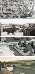 The 1849 and 1862 Boscawen Bridges
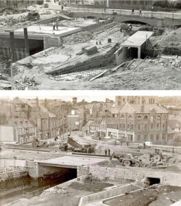 Constructing Morlaix Avenue in the 1960s (Photos: Susan Coney)
We are now within a few metres (or yards if you prefer) of the point where Truro’s two main inner-city rivers converge and we turn our attention to the River Kenwyn.
River Kenwyn
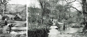 Little Canaan – up-river from Newmills, near Treliske Hospital / New Mills
The River Kenwyn (Dowr Ithy) begins its journey quite a few miles from Truro, with one source beginning its journey at Shortlanesend and the other to the west, at Four Burrows. They combine to the west of New Mills before heading off towards the city.
The River Kenwyn within Truro
Having left the comparative peace of the countryside, the Kenwyn passes under a two-span road bridge at the bottom of Comprigney Hill and begins its journey through Truro’s urban area. (I seem to recall this being referred to as Bosvigo Bridge). (11)
It runs down the rear gardens of St George’s Villas which was a section prone to flooding. I had relations living there and on one occasion my Aunt was ‘trapped’ in the first floor with her very young baby. I remember this stretch of river in full flow before flooding across her back garden although I cannot recall seeing it entering the house.
Just before reaching the viaduct, the river ran under St George’s Road to emerge again on the other side where an 18th century leat (Tregeare Water) (12) split from it. It was in this area of Carvedras, in the early 1890s, that Waterfall Garden was opened and flood alleviation measures were taken to overcome the flooding problem further up stream.
The river and the leat travel side-by-side just below the 1898 Victoria Gardens albeit the river is at a much lower level than the leat. It is a delightful place for a stroll with an occasional look over the wall to see the river as it hurries along. The leat was where we once sailed our model yachts in its relatively still waters, relative, that is, to the busy River Kenwyn.
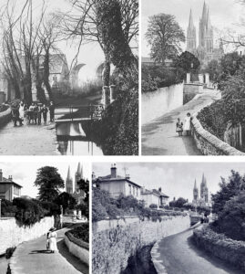 A lovely place for a promenade – the leat on the left and the River Kenwyn on the right
The twin waterways soon reach Edward Street where they pass under its circa 1830s bridge. (13) Here was one of many locations where steps down to the river enabled water to be collected for domestic use.
The waters emerge again but soon pass under the circa 1830s Castle Street Bridge (14) and it’s just beyond this point that their journeys diverge.
Tregeare Water (The Leat) maintains its line and once travelled along fully exposed to the open air. It provided water for the streetside channels and a sufficiently powerful flow to turn the Town Mill (15) waterwheel (demolished 1837) before returning to the Kenwyn just beyond West Bridge.
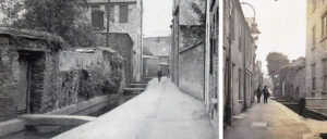 The Leats in the early 1930s. Pity the poor soul who, returning from an convivial evening, had to traverse the granite crossing to their home.
Eventually though, the fortunes of Tregeare Water changed and in the 1960s it was covered over and the resultant street was given the appropriate name of ‘The Leats’.
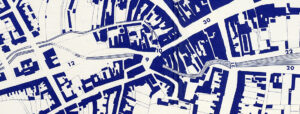 Exploded view of R Symons’ map showing the line of the River Kenwyn before it was built over.
(9) West Bridge (10) Town Mills taking power from Tregear Water (12) Proposed River Street (30) Boscawen Street – included to aid location (21) Lemon Bridge (20) Lemon Quay (22) Back Quay
The River Kenwyn, having lost its travelling companion, took a sharp right just beyond Castle Street Bridge and headed off towards what became River Street. Having reached that point, it turned left and made its way towards West Bridge in what became Victoria Place, providing pickings for scavengers and birds from its muddy banks as it trundled along.
River Street was built in the 1840s, roughly on the line of the River Kenwyn which was then driven underground. The development to the left of the new street included the 1845 Truro Savings Bank (later the Museum – RIC), a Baptist chapel circa 1850 and a new Bethesda Chapel in 1857.
The 15th century wooden West Bridge, (16) a hump-backed design with a ford beside it, crossed the River Kenwyn and linked St Nicholas Street with Street Kenwyn. It was later re-built in brick and the river was culverted by a twin-arch structure. This bridge was removed in the redevelopment and the area which we now know as Victoria Square (previously Victoria Place) was covered over and the River Kenwyn became subterranean from Castle Street to there.
The new River Street provided a direct route into the town but it brought with it an increased risk of flooding as the culverts often became obstructed by debris requiring the tunnels to be regular cleaned to prevent blockages.
The area of River Street, Victoria Square and St Nicholas Street became prone to dreadful flooding and in the winter of 1848/49 the depth of water in some places was recorded as almost six feet. Many newspapers carried the stories which continued throughout the winter. (17) (Royal Cornwall Gazette – Friday 02 March 1849 / Penzance Gazette – Wednesday 03 January 1849) It became so bad that in 1971, extensive improvements and repairs were carried out to the tunnels in an attempt to overcome the problem.
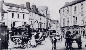 Victoria Square, near where West Bridge once stood. The area has been covered over and on the extreme left is the old Iron Duke men’s urinal: located, of course, over the river! This edifice was removed in the 1950s.
From Victoria Square the Kenwyn ran alongside the Ship Inn (later Victoria & Ship Inn Beer House / Victoria Inn / Victoria Coach) and in January 1738, with flood water four feet high, the landlord, John Roberts, had to be rescued by boat. By 1762, Richard Roberts, the then landlord, wished to enlarge his premises and extended the dining room over the river.
Beyond this, and now open to the air, the Kenwyn continues its merry journey behind the houses in Walsingham Place before snaking its way towards where Lemon Bridge was located.
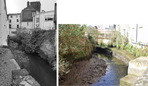 The Kenwyn at the rear of Walsingham Place (Photo: Lee Trewhela)
It was here, circa 1949 that, “Two carriage houses at the back of Pearce’s Hotel had their foundations swept away by the surging Kenwyn River and three large carriages were carried off to pile up against Lemon Bridge.” (18) A History of Truro Volume 1,
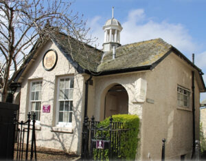 The 1925 gent’s toilets at the bottom of Lemon Street, just above where Lemon Bridge was located
The 1798 Lemon Bridge (19) once stood in glorious isolation providing a route from the new Lemon Street to Boscawen Street. It remained as such for over 130 years when it was incorporated into a much bigger plan.
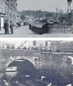 The top photograph shows an old vehicle chugging up Back Quay towards Lemon Bridge whilst the bottom one shows a view of the bridge from down river
Flanking the Kenwyn here was Back Quay (20) to the north, and Lemon Quay (21) (previously Merchant’s Quay) to the south, where many small industries operated and greatly contributed to Truro’s growth. The name ‘Back Quay’ is rarely used these days but it was once described as the most important medieval quay in Truro.
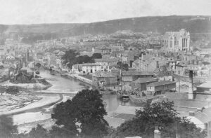 The River Kenwyn circa 1900 with Brunel’s masonry and wood viaducts and the unfinished Cathedral in the background. Lemon Bridge is in the distance and timber ponds are in the bottom left corner.
These next few photographs show Back Quay and Lemon Quay, busy places providing loading and unloading locations for some quite large craft. At low tide however, the river was considerably less attractive.
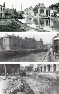 Lemon Bridge, the lower two with the 1925 toilets in place
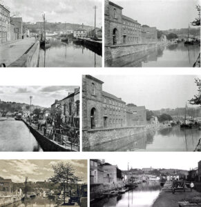
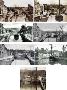
Over time the navigable stretch of the Kenwyn River has shrunk. We have already seen that the length along what is now River Street was covered over to provide one of the main thorofares into Truro.
Now, we come to a decision which must have caused a great deal of debate and heartache and one where there is a lingering regret at a lost opportunity. Undoubtedly the river was being used for both human and commercial waste: it was full of detritus and the smell at low tide was described as dreadful. Something had to be done but rather than tackle the root cause, the decision was that it should be hidden from sight. From a little up river from Lemon Bridge, down to where the Bus Station now stands on ‘The Green’, it was concreted over – albeit in two sections, one in the mid-1920s and the lower section in the 1930s.
Now, as we reflect on what was a golden opportunity to create an attractive leisure area, we must have sympathy on those who made the decision but what a lovely waterside spot it could have been.
The decision to enclose the area dates from the early 1920s and as ever, there were photographers on hand to record its progress.
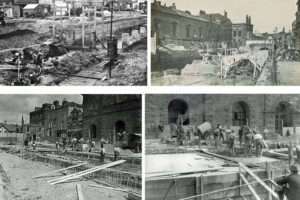 Early/mid-1920s forming the tunnel
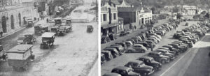 The first phase complete and in use / Completion of the second phase
It remained in use as a car park for many years but it is now a recreational area often used as an open-air shopping market. It is often referred to as ‘The Piazza’, a name which annoys many and one which has no official recognition whatsover. It was simply a temporary working name ascribed to it when the construction work was in progress. Truronians still refer to this area as Back Quay and Lemon Quay and long may that continue.
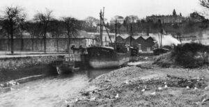 A freighter stands alongside ‘The Green’ in the remaining length of the River Kenwyn not covered with concrete
This short stretch of water has been the cause of some excitement and tragedy over the years, some of which connects it with the Britannia Public House, on the other side of The Green. For many years there were no railings between The Green and the river and a number of Britannia customers have fallen into the water and drowned whilst trying to find their way home.
A more fortunate customer was Francis Harry who left the Britannia Inn by its back door in 1864, crossed The Green and headed for the lamps on Lemon Quay – on the other side of the river! Unfortunately with no railings on the quayside and, obviously having forgotten the River Kenwyn was in his path, he fell straight in. Luckily, help was on hand and he was quickly pulled to safety and taken to the William the IV public house where he recovered.
February 1883 saw a week of excessively high tides which caused flooding throughout Truro. In Old Bridge Street, the Barley Sheaf and the Old Bridge Street Inn were flooded with the latter’s cellar being full to the ceiling. The water was up to the door of the Britannia Inn and several persons were obliged to stay there until the tide receded. They were then able to leave, presumably with a note of explanation for their wives!
Another story with a happy ending relates to a young lady who was rescued from this stretch of water. Her journey seemingly began in Waterfall Gardens in St George’s Road, where she fell into the river. She was swept along the swollen river, both above and below ground, until strong hands pulled her to safety. An amazing story but apparently true as it appeared in a newspaper!
A controversal move in the 1980s involved placing the Compton Castle, a river paddle steamer, in the remaining length of water. Initially operating as a restaurant, it later became a flower shop before being deserted to the elements until the mid-1920s when it was broken up and removed.
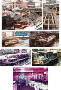 The Compton Castle – arrival and installation (Photos: courtesy John Wilson)
We now come to the point where the Rivers Allen and Kenwyn converge to form the Truro River. This, of course, includes the waters of the ‘Glasteinan’.
‘The Glasteinan’
There is an element of doubt that this little river was actually given this name but we do know that whatever it was called, it began its journey from an area of that name so it is understandable that it became known as such. It was once more prominent but is now smaller and underground as it makes its way down the line of Tregolls Road before entering the River Allen near Boscawen Bridge. Referred to by some as the Tinney, presumably a shortened version of its name, its full name does sound grand for what is now, an underground stream.
Truro City Council clearly recognised the full name as this 2021 report shows: “Glasteinan Woodland in Beechwood Parc has been developed over the last year with lots of rubbish being cleared out with community groups, development of a Riverside walk, lots of newly planted trees, new boardwalks and accessible steps now make it a very beautiful area to visit. Running alongside the river Glasteinan, the added light from some winter thinning works has really helped encourage ground flora.” (22)
The confluence of the Rivers Kenwyn and Allen
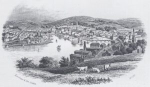 From Poltisco mid-19th century with St Mary’s Church and the curved wooden Boscawen Bridge
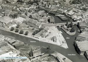 The thick white arrow indicates the approximate point where the Glasteinan (probable name) joins the Allen. Boscawen Bridge replaced an earlier wooden structure and the adjacent Worths Quay was added circa 1900.
At the point where the Kenwyn and Allen meet is the 17th century Town Quay, (23) an important and busy location. It’s importance must have increased further with the construction of New Bridge and Boscawen Bridge and the covering in of the Kenwyn restricting access and the size of craft which could travel to the upper reaches of the rivers.
Truro River
In the late 19th century, Truro was losing its importance as a port and the closure of its two remaining tin smelting houses (Calenick in 1891 and Carvedras in 1898) came as a further severe blow. (24)
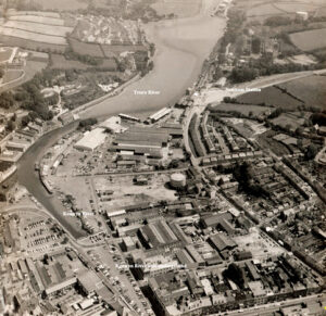 Truro River with its narrow channels (1960s Photo: courtesy Pat Nankivell)
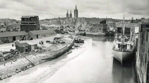 1950s with the old Truro Gas Works soon to be replaced by a new one further down river. On the left is the extensive Garras Wharf. (Photo: Lyndon Allen)
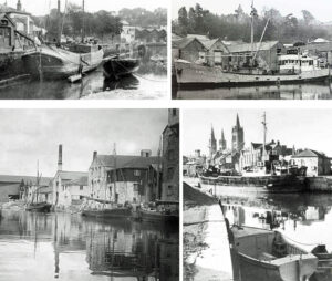 Busy River Scenes (Photos: courtesy Lyndon Allen)
The Quays
There were many small quays within the city and some of these have already been mentioned but many were located where the rivers widened and others on the flanks of the broad Truro River.
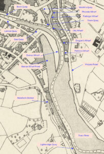 Most of the following are shown on the map above and information about them can be accessed by using the Heritage Gateway links.
Dragon’s Wharf: Heritage Gateway – Results
Duchy Wharf: Heritage Gateway – Results (Shown on confluence map)
Eny’s Quay: Heritage Gateway – Results (Shown on confluence map)
Garras Wharf (previously Andrew’s Wharf): Heritage Gateway – Results
Garras Wharf Pond: Heritage Gateway – Results
Lighteridge Quay (1950s) (Dynamite Quay): Heritage Gateway – Results (Located opposite Boscawen Park and not shown on quay map)
Newham Quay: Heritage Gateway – Results
Poltisco Wharf: Heritage Gateway – Results
Town Quay (17th century): Heritage Gateway – Results
Waterloo Quay: Heritage Gateway – Results (not shown on quay map)
Worth’s Quay: Heritage Gateway – Results
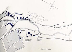
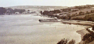 Waterloo Quay, beside the road to Malpas, was once just up-river from where Boscawen Park was created: it was where sailing vessels accessed ballast
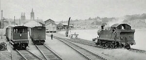 Newham Station
In 1855 the West Cornwall Railway opened the line through to its new terminus at Newham but just four years later, Truro Station opened in its present location and Newham’s status began to diminish. In 1863 the passenger service closed there and it became a goods depot only, a purpose it retained until 1971.
The sight of steam trains in use at Newham, to the left of the Truro River as you approach the city, is still recalled by many but now there are few signs that a railway ever operated there.
Shipping Companies
Like other coastal and river locations, wooden ship building was a steady occupation and yards were located from Truro to Malpas.
Shipping companies flourished and from 1814 to 1876 the Truro Shipping Company operated from its warehouses on Back Quay. Following this, was the R B Chellew Steam Navigation Co. which was founded in Truro and operated from 1882 until well into the 20th century from its offices in the Corn Exchange. It worked out of Joseph Ferris’ wharfs and warehouses on the River Kenwyn and from Enys Quay on the River Allen. Both companies ran ships with very Cornish names including City of Truro, Duke of Cornwall and Duchess of Cornwall
From the 1840s there was a river passenger service between Truro and Falmouth and out of this developed the pleasure cruise businesses which still operate today.
Well there we have it. I’m sure that there is much more which could be added but I hope that this is of interest and may have helped resolve a few mysteries but what we should all agree on is that all of Truro’s waterways have played a hugely significant role in the development of the city.
End notes:
- West Briton August 1873
- Moresk Bridge: (Heritage Gateway – Results)
- A History of Truro Volume 1. ISBN 1 873443 34X
- Penzance Gazette – Wednesday 03 January 1849
- Mill Pool: (Heritage Gateway – Results)
- ‘Tardis’ House: (Heritage Gateway – Results)
- East Bridge (Heritage Gateway – Results)
- New Bridge: (Heritage Gateway – Results)
- Furniss Island (Heritage Gateway – Results)
- Boscawen Bridge: (Heritage Gateway – Results)
- Bosvigo Bridge: (Heritage Gateway – Results)
- Tregeare Water: (Heritage Gateway – Results)
- Edward Street Bridge: (Heritage Gateway – Results)
- Castle Street Bridge: (Heritage Gateway – Results)
- Town Mill: (Heritage Gateway – Results)
- West Bridge: (Heritage Gateway – Results)
- Royal Cornwall Gazette – Friday 02 March 1849 / Penzance Gazette – Wednesday 03 January 1849
- A History of Truro Volume 1. ISBN 1 873443 34
- Lemon Bridge: (Heritage Gateway – Results)
- Back Quay: (Heritage Gateway – Results)
- Lemon Quay: (Heritage Gateway – Results)
- Truro City Council Countryside Ranger, Chris Waddle 19th March 2021
- The Kenwyn and Allen Confluence: (Heritage Gateway – Results)
- A History of Truro Volume 2. ISBN 1 873443 43 9

Tony Mansell is the author of several books on aspects of Cornish history. In 2011 he was made a Bardh Kernow (Cornish Bard) for his writing and research, taking the name of Skrifer Istori. He has a wide interest in Cornish history, is a researcher with the Cornish National Music Archive and co-editor of Cornish Story.

Hi Tony,
Very interesting article. I am interested in the image of Lemon Quay. I have a reproduction of it. Do you know anything about who might have taken the image and where the original is, please?
Best Regards,
John Roote
Thank you John. I’m afraid I don’t know the origin of that photo. I have been given many prints over the years which i have tucked away for a rainy day and that is one of them. I would like to discover the originator and add a credit. Best, Tony