
 Map:
Map:
This profile of Pendoggett Wesleyan Chapel has been compiled by Jo Lewis and Tony Mansell
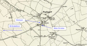
Entering Pendoggett from the west on the B3314, the first Pendoggett chapel can be found to the left of the road opposite the right turn to St Kew, tucked behind the cottages on the main road. May have gate access but can’t be seen from road on google view
It is marked as a Wesleyan Chapel on 1880 maps. There is an early Trust deed for a Wesleyan Chapel at Pendoggett from 1830 which is likley build date.
All that piece, parcel or spot of ground containing by admeasurement thirty feet in length and twenty feet in breadth sitaute in the village of Pendoggett in the parish of St Kew and bounded on the east by a house the property of the said James Philp, on the west be a public high way leading through the said village of Pendoggett, on the south by a waste spot of land behind the said house belonging to the said James Philp and on the north by the lands of Lord Grenville, and also all that building tenement or house known by the name of the Methodist Chapel and curtilage lately erected and built in and upon the said piece or parcel of ground… upon Trust. Deed enrolled in Chancery, 2 June 1830. Pendogget is marked as a methodist preaching place on an old map 1789 – 1834). Kresen Kernow document: https://kresenkernow.org/SOAP/detail/201aed4c-f4d0-4d0f-8a7e-773caaa1deb0/?tH=%5B%22pendoggett%22%5D
1854: Aligned with the United Free Methodists from 1854.
1894: When the second chapel was built it became the Sunday school.
1970s: Became redundant.
Became residential.
Other Kresen Kernow documents: https://kresenkernow.org/SOAP/search/pendoggett/