
 Map:
Map:
This profile of Porthcollum Bible Christian Chapel was compiled by Jo Lewis.
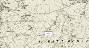
Porthcollum Chapel lies south east of St Erth. Follow the Porthcollum Lane from St Erth Hill for some distance and the Chapel was at the junction with Countess Bridge Lane.
Heritage Gateway: The Bible Christian magazine of 1851 recorded a Bible Christian chapel at the junction with Porthcollum lane (1), however, the c1840 Tithe survey records it as a dwelling house (TA1324) (2). A building is recorded on historic Ordnance Survey maps at this location but it is not named as a chapel so was presumably not used for religious purposes by this time (3-4). Appleby records that there are no extant remains (5), however, modern mapping shows that the current hedge line incorporates part of the building (6).
https://www.heritagegateway.org.uk/Gateway/Results_Single.aspx?uid=MCO10127&resourceID=1020