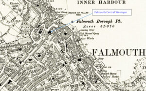
Map: https://maps.nls.uk/geo/explore/side-by-side/#zoom=10.4&lat=52.44811&lon=-3.07812&layers=6&right=ESRIWorld This profile of Falmouth Central Wesleyan Chapel has been compiled by Jo Lewis and Tony Mansell. Located in Market place, on the southern side of The Moor. In the mid-C18, the Falmouth Methodists were meeting in a room on Porhan Hill, and there was probably also a meeting place off Church Street. John…Continue Reading “Mapping Methodism – Falmouth Central Wesleyan Chapel”