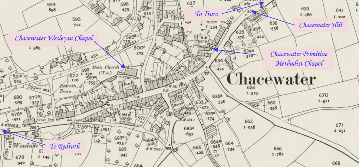
Chacewater is a village and civil parish in Cornwall, situated approximately 3 miles (4.8 km) east of Redruth. This profile of Chacewater Wesleyan Chapel has been compiled by Jo Lewis and Tony Mansell.   Large Wesleyan chapel with rear schoolroom (1832). Chapel part altered 1905. Classical style with front pediment and round arches; quoin and…Continue Reading “Mapping Methodism – Chacewater Wesleyan chapel”

Ashton is a village in the civil parish of Breage on the A394 Penzance-Helston road one mile north-east of Praa Sands. This profile of Ashton UMFC has been compiled by Jo Lewis and Tony Mansell.   “Today none of the original four chapels in Ashton are used for religious purposes, reflecting a general trend in…Continue Reading “Mapping Methodism – Ashton United Methodist Free Church”

Ashton is a village in the civil parish of Breage on the A394 Penzance-Helston road one mile north-east of Praa Sands. This profile of Ashton Bible Christian Chapel has been compiled by Jo Lewis and Tony Mansell.   “Today none of the original four chapels in Ashton are used for religious purposes, reflecting a general…Continue Reading “Mapping Methodism – Ashton Bible Christian Chapel”

Twelveheads is a hamlet east of St Day in the parish of Chacewater between Truro and Redruth. The name comes from its mining history. Sets of stamps, machines for crushing ore, were once used on the dressing floors in the village. The stamps had a total of twelve ‘heads’. Billy Bray, the Methodist preacher, was…Continue Reading “Mapping Methodism – Bethel (Twelveheads) Bible Christian Chapel”

Goon Piper is a hamlet in the parish of Feock. This profile of Goon Piper (Feock) Wesleyan Chapel has been compiled by Jo Lewis and Tony Mansell.   A Victorian Wesleyan Methodist chapel of rubble masonry construction under a slate roof, designed by Silvanus Trevail and built in 1818 (earlier chapel). The SW elevation is…Continue Reading “Mapping Methodism – Goon Piper (Feock) Wesleyan Chapel”