Mapping Methodism – East Portholland Wesleyan Chapel

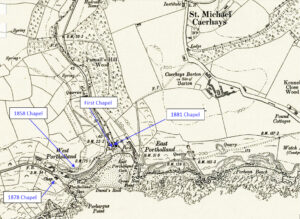
Map: https://maps.nls.uk/geo/explore/side-by-side/#zoom=10.4&lat=52.44811&lon=-3.07812&layers=6&right=ESRIWorld This profile of East Portholland Wesleyan Chapel has been compiled by Jo Lewis and Tony Mansell. The chapel overlooks the cove from the west bank of the brook dividing east from west.   First East Portholland Wesleyan Chapel Heritage Gateway: Wesleyan chapel, later a Sunday school from when 1881 chapel built alongside, now…Continue Reading “Mapping Methodism – East Portholland Wesleyan Chapel”

Mapping Methodism – Porthcollum Bible Christian Chapel

Map: https://maps.nls.uk/geo/explore/side-by-side/#zoom=15.0&lat=50.16118&lon=-5.41344&layers=6&right=ESRIWorld   This profile of Porthcollum Bible Christian Chapel was compiled by Jo Lewis.   Porthcollum Chapel lies south east of St Erth. Follow the Porthcollum Lane from St Erth Hill for some distance and the Chapel was at the junction with Countess Bridge Lane. Heritage Gateway: The Bible Christian magazine of 1851 recorded…Continue Reading “Mapping Methodism – Porthcollum Bible Christian Chapel”

Mapping Methodism – Wheal Alfred Wesleyan Chapel

Map: (https://maps.nls.uk/geo/explore/side-by-side/#zoom=16.0&lat=50.18276&lon=-5.39698&layers=257&right=ESRIWorld)   This profile of Wheal Alfred Wesleyan Chapel has been compiled by Jo Lewis.   Wheal Alfred Chapel lies south of Hayle but is best accessed by taking the Wheal Alfred Road from Ventonleague It was built circa 1815 for the local mining community – the hamlet itself was named for the local…Continue Reading “Mapping Methodism – Wheal Alfred Wesleyan Chapel”

Mapping Methodism – Hallancoose Wesleyan Chapel

Map: https://maps.nls.uk/geo/explore/side-by-side/#zoom=14.9&lat=50.18067&lon=-5.34009&layers=6&right=ESRIWorld   This profile of Hallancoose Nonconformist Chapel has been compiled by Jo Lewis.   Heritage Gateway: A Wesleyan Methodist chapel is recorded on the 1st and 2nd Editions of the 1:2500 1880 and 1907 OS Maps. The remains of part of the chapel are shown in the road verge on the modern Mastermap….Continue Reading “Mapping Methodism – Hallancoose Wesleyan Chapel”

Mapping Methodism – Bedford Road Methodist New Connexion/Wesleyan Church, St Ives.

  Article written by Val Thomas, St Ives Old Cornwall.   Bedford Road was built in 1899 on land originally owned by Edward Hain of The Terrace, then Treloyhan. He also owned the Manor House opposite the chapel which was in an area then called Green Court. This building had originally been owned by the…Continue Reading “Mapping Methodism – Bedford Road Methodist New Connexion/Wesleyan Church, St Ives.”