Mapping Methodism – Sancreed Non-Conformist Chapel

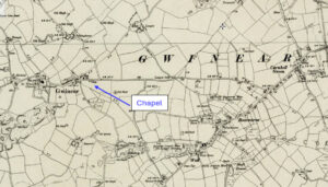
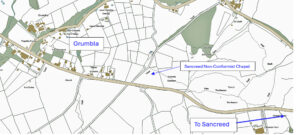
Sancreed Non-Conformist Chapel has been profiled by Jo Lewis and Tony Mansell   Little has been found about this chapel. Non-Conformist Chapel (19th century – 1801 AD to 1900 AD) (HER) Heritage Gateway notes a post mediaeval chapel north of the Sancreed to Grumbla Road. Methodist chapel, now converted to house. To be inspected. There…Continue Reading “Mapping Methodism – Sancreed Non-Conformist Chapel”

Mapping Methodism – Gwinear Wesleyan Chapel

Map: https://maps.nls.uk/geo/explore/side-by-side/#zoom=15.0&lat=50.18785&lon=-5.35617&layers=6&right=ESRIWorld   This profile of Gwinear Wesleyan Chapel was compiled by Jo Lewis.   Approaching Gwinear from the East, the Wesleyan chapel was south of the road, set down a short track in a field. There is still a gap in the wall at this point, just before the houses start on the right but no…Continue Reading “Mapping Methodism – Gwinear Wesleyan Chapel”

Dairy Schools

The Dairy School at Blackwater in 1916 – local girl Olive James on the left. Dairy Schools were once an important part of rural life: they fulfilled a need and were gone by the 1930s. Considering that, perhaps it is not surprising that few have even heard of their existence.   The Technical Instruction Act…Continue Reading “Dairy Schools”