This profile of Treviglas United Methodist Chapel has been compiled by Jo Lewis and Tony Mansell.
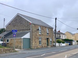
 (Photo: Jo Lewis 2021)
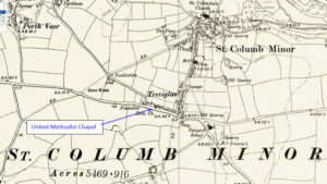
Treviglas lies on the east edge of Newquay, near St Columb Minor. The chapel is on the north side of Henver Road before the turn to St Columb Minor.
The society was formed here in 1854.
Heritage Gateway: A United Methodist chapel is recorded on the main road out of Newquay at Treviglas on the 1st Edition 1:2500 OS map c1880. Recorded on the 2nd Edition OS map 1:2500 c1907 as a Free United Methodist chapel. Former chapel, probably mid-C19 with two round-arched windows to road. Converted prior to 1973. Listed in Stell (b1).https://www.heritagegateway.org.uk/Gateway/Results_Single.aspx?uid=MCO52049&resourceID=1020
1872: Built as a United Methodist Chapel and probably considered a part of St Columb Minor.
1907: The Methodist New Connexion, Bible Christians and United Methodist Free Churches amalgamated to become the United Methodist Church.
1907: Became a Free United Church.
1932: The Wesleyan, Primitive Methodist and the United Methodist Church amalgamated to become the Methodist Church of Great Britain.
1932: Became the Bethel Methodist Church.
1940: Seating for 98. (Revd David Easton)
1983: The chapel closed and the congregation joined with St. Columb Minor Wesley to whom capital of £7000 was given.
There are accounts and minutes until 1984.
Building converted to residential use and is now called The Old Chapel.
Further reading:
https://kresenkernow.org/SOAP/search/RelatedNameCode.keyword/CRO%7CUK%7C988/

 Map:
Map: