
 Map:
Map:
This profile of Lane Wesleyan Chapel has been compiled by Jo Lewis and Tony Mansell.
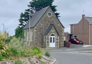 Lane Wesleyan Chapel (Photo Jo Lewis)
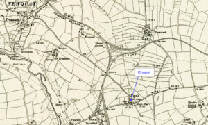
Located at the north-eastern corner of the A392 roundabout, where it meets the Treloggan Road connection to Newquay. This small chapel is a familiar landmark.
Build date: 1879.
1879: New Wesleyan Chapel. A pretty little chapel has just been completed for the Wesleyans at Lane, about one-and-a-half miles from Newquay. The chapel is lighted by lancet windows filled with frosted glass; the seats are of varnished pine. Altogether the edifice is very creditable to Mr. Thomas Came, of Newquay, the architect, and Mr. Bennetto, of Newlyn, the builder. The chapel was opened on Tuesday afternoon, when an able sermon was preached by the Rev. J. S. Pawlyn, of Truro. (West Briton and Cornwall Advertiser – Thursday 29 May 1879)
Heritage Gateway: Wayside Wesleyan chapel survives at Lane. Local rubble with granite dressings under a steep roof. Simple Gothic style with pointed-arched openings. 3-window side elevations; gabled porch to front end. It is recorded on the modern OS Mastermap 2007 and annotated “Chapel of Rest”.
https://www.heritagegateway.org.uk/Gateway/Results_Single.aspx?uid=MCO32952&resourceID=1020
1881: Appears on maps.
1932: The Wesleyan, Primitive Methodist and the United Methodist Church amalgamated to become the Methodist Church of Great Britain.
1932: Became Lane Methodist Church.
1940: 110 seats. (Revd David Easton)
1961/62: Closed. (Revd David Easton/SWChurches)
Became a funeral director’s chapel of rest.
2024: Being converted to residential.