
 Map: (
This profile of Wheal Alfred Wesleyan Chapel has been compiled by Jo Lewis.
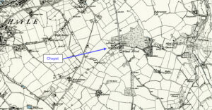
Wheal Alfred Chapel lies south of Hayle but is best accessed by taking the Wheal Alfred Road from Ventonleague
It was built circa 1815 for the local mining community – the hamlet itself was named for the local copper mine
1815: Paper, Wheal Alfred Wesleyan Chapel, Phillack – paper showing election of new trustees with copy of trust deed, 1815, attached, by which permission granted for building of meeting house. (Kresen Kernow Ref: MRIHY/46 dated 6th Nov 1822)
It was registered on the 1867 register. https://www.mywesleyanmethodists.org.uk/content/research-resources/chapels-research-resources/registration/registered-wesleyan-methodist-places-of-worship-in-cornwall-1867
Recorded on the 1st Edition 1:2500 OS Map of 1880.
Marked as a Wesleyan Methodist Chapel on 1880 maps it is no longer marked by 1908 but building remains.
Heritage Gateway entry: A Weslyan Methodist chapel, recorded on the 1st Edition 1:2500 OS Map of 1880, survives at Wheal Alfred. It was a chapel for the local mining community.(b1). https://www.heritagegateway.org.uk/Gateway/Results_Single.aspx?uid=MCO10373&resourceID=1020