
Mapping Methodism – St Erth Wesleyan / Bible Christian Chapel
Categories Mapping Methodism, Projects0 Comments
St Erth is a village four miles southeast of St Ives and six miles northeast of Penzance. This profile of St Erth Bible Christian Chapel has been compiled by Mike Millichamp and Tony Mansell
A history of St Erth Wesleyan / Bible Christian Chapel by Mike Millichamp
The Bible Christian Church was a Methodist denomination founded by William O’Bryan, a Wesleyan Methodist local preacher in 1815.
The earliest record of practising Methodists in St. Erth is 1783. Later in 1796 the first Wesleyan Methodist Chapel was built at Churchtown and was used until 1827 when they moved to their current site.
They left behind a purpose-built building albeit rather simple but too small for the Wesleyans. It had a seating capacity for 40 but 55 persons regularly attended.
This was then converted and occupied by the local blacksmith and then by the Bible Christians sometime later. The 1851 Census of Places of Public Worship indicates that the chapel was extant and John Parsons was the minister.
The 1877 Ordnance Survey map shows the existence of the building and a local newspaper report of 1891 confirms that it was flourishing when the stone Churchtown cross was re-erected outside the Chapel wall.
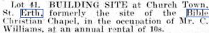
It was abandoned in 1907 as a place of worship.
The 1908 Ordnance Survey map shows no trace of the building.
It has long since been demolished and the site divided and it would appear the current Post Office and General Stores has been built on part of the site with a new house on (perhaps) the road entrance.
While researching the Wesleyan Chapel at St Erth I came across this article which explains the position of the Bible Christian Chapel at one time. I have no doubt that worship was originally carried out in a barn or home, but by the time the 1891 article was written (see below), the Bible Christians were worshipping in the original meeting room, built in 1796 by the Wesleyans. In 1827 the Wesleyans built a larger chapel on glebe land at the bottom of the hill nearer to the river so the building was used as a smithy prior to the Bible Christians taking it over. (Val Thomas)
The Wesleyan Methodists had a chapel in the Churchtown, and at St Erth Praze; the Bible Christians also had a chapel in the Churchtown. (Genuki)
The site of a Bible Christian chapel, recorded on the 1st Edition 1:2500 OS map, but demolished by the time of the 2nd Edition map c1907. Gravestones found on the site (31981) are probably not associated with the chapel as they are C18. (Cornwall Council Heritage Gateway)
In 1796 the first Methodist chapel was built up at the cross where the post office is now. Before that a ‘hired’ room was used. This was used by the Wesleyans until 1827 after which it had various uses. By 1851 Independents and Bible Christians were using it for worship and it eventually became St Erth Bible Christian chapel, closing c. 1906. The Bible Christians were a Methodist group dating from 1815 and first appeared in St Erth in 1837. (St Erth Methodist Chapel http://www.st-erth.co.uk/methodist-chapel.html
1783: The earliest record of the St Erth Methodist Society is for Easter. (St Erth Methodist Church – Cedric Appleby)
Hired room used for services. (St Erth Methodist Church – Cedric Appleby)
1796: Built as a Wesleyan Chapel.
Seating for 40. (Mike Millichamp)
1827: The Wesleyans vacated the building. (St Erth Methodist Church – Cedric Appleby)
Building used as a smithy.
1837: Bible Christians meeting in St Erth. (St Erth Methodist Church – Cedric Appleby)
1851: St Erth Bible Christians using the old Wesleyan Chapel / Smithy.
1878: Shown on map as a Bible Christian Chapel. https://www.old-maps.co.uk/#/Map/155129/35062/12/100115
1888: Shown on map as a Bible Christian Chapel. https://www.old-maps.co.uk/#/Map/155129/35062/10/100114
1891: It was a Bible Christian chapel at the time this newspaper report:

(The Cornishman Thursday 5th November 1891) Briefly the article explains:
- The land belonged to the St Aubyn family.
- The cross, which is still in position and is listed by English Heritage, was originally enclosed within the wall of the Wesleyan Meeting house.
- The wall enclosing the cross was adjusted and the height of the cross was exposed.
- At the time of writing the newspaper article it was still being used by the Bible Christians.
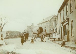
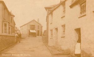
The caption reads 9th August 1905. St Erth P O and Cross – site of old chapel, probably centre background (Photo: Edward Offer, courtesy Mike Mycetes) Mike Mycetes adds, “The cross is still there; the building identified as the Chapel has long since been demolished and the current Post Office Stores stands on part of the site. The bystanders are next to the old Post Office which is now a private house.”
Circa 1906: St Erth Bible Christian Chapel closed. (St Erth Methodist Church – Cedric Appleby)
 The chapel has now been demolished but the post office has yet to be built (Photo: courtesy Mike Mycetes)
St Erth Bible Christian Chapel demolished.
 (Cornish Telegraph Thursday 10th April 1913)
 (Cornish Telegraph Thursday 3rd July 1913)
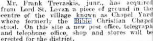
Post Office built on the site.
 The new post office located on the site of the demolished chapel (Photo: courtesy Mike Mycetes)
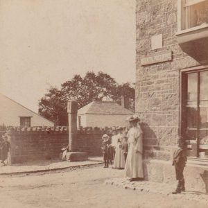
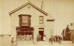 The Post Office, built around 1907 on the site of the original chapel. The cross can be seen to the right of the building. The crossroads is known as Church Cross. The wall described in the newspaper article was replaced by the side wall of the Post Office. (Photo: courtesy Mike Mycetes)
1908: No longer shown on map as a Bible Christian Chapel. https://www.old-maps.co.uk/#/Map/155016/35135/10/101039