
Having already introduced us to Barripper, David Oates now moves a short distance to the north to acquaint us with another area which he knows so well. Stay tuned as there will be a third article from David later in the series.
The village of Kehelland sometimes struggles to justify the term “village” – it has no pub, no shops now and compared to larger rural settlements throughout the county, seems at first glance to be of little significance. It lies between Camborne and the north coast and is on no major modern route. Indeed, before the decision in 1839 to build the turnpike road between Camborne and Hayle it was remote indeed and large parts of the area were unenclosed downland. It does have within its compass, however, some small settlements all of which are in easy walking distance of the village and which have always seen Kehelland as a focal point. These might struggle to be even called hamlets but their historical importance to the whole area makes them well worthy of inclusion in any narrative about the village of Kehelland as their existences are closely linked. Three are especially significant – Roseworthy, which lies on the A3047, the route of the 1839 turnpike, Menadarva, the name of which takes us back to the Dark Ages and Treswithian Downs, now enclosed farmland but clearly open downland at a previous time.
It is important to note that these settlements, like most in Cornwall, were part of the fiefdom of an aristocratic estate – in this case the Bassets of Tehidy.
Kehelland is of some antiquity – or at least the name is and appears in documents about the Parish of Camborne as early as the 13th century – and it sits on an important ancient route in the old parish of Camborne the “churchway” linking Camborne Church to Gwithian parish. At first glance it would seem to have been an entirely rural, farming community but the reality is far more complicated than that. There has always been farming in the area but also open, uncultivated land, indicated by the local place-name “Treswithian Downs” which was once an unenclosed area where the militia would go on manoeuvres. This seems to be evidenced by looking at the churchway on a map, which shows it going from Camborne parish Church, through Kehelland and to Menadarva, close to the boundary with neighbouring Gwithian parish in an absolutely straight line, hinting at the fact that in earlier times the whole are west of Camborne, which includes Kehelland, was open and unenclosed with no physical obstacles to cause a deviation in the churchway. Indeed, in the 1841 census, the entries for Treswithian Downs are followed by entries for Kehelland Downs, reinforcing the fact that these were large, open areas.
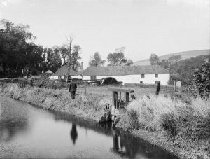
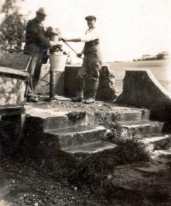 The water supply at Kehelland before mains water
In the valley very close to Kehelland, and directly on the churchway, and certainly now within the village’s sphere of influence, lays the small settlement of Menadarva – of great historical interest locally and particularly within the old parish of Camborne. That settlement is very close to what was the major tin-streaming area of the Red River valley and people using the churchway or, more directly, the Red River valley route could very quickly access some of the major mines in the Camborne area around Tuckingmill and Pool. This mining connection is clearly shown in the 1841 census which reveals much about the village and its environs. Firstly, there was a much larger population than nowadays. Families were large but records taken in what are now uninhabited parts of the area or for place-names that no longer exist, suggests there were many, many more dwellings than now. Walk through any lane around Kehelland and you will see places where the verge was wider than normal to accommodate a cob cottage. Indeed in a few of these locations careful examination still reveals the remains of the cob walls. Once abandoned, these crudely built cottages would have quickly succumbed to the ravages of the weather and literally washed into the ground. Secondly, the 1841 census entries show very clearly what the dominant occupations were. Locations that were, and still are, farms, show the occupation of farmer or agricultural labourer. Other expected rural occupations are also recorded – miller, blacksmith for example. One entry lists the occupation of a farmer’s son as “wool comar” (sic). However, the overwhelming occupations listed in the Kehelland area are connected with the mining industry – copper miner, copper dresser or copper boy and copper girl – these last two being recorded as working in the industry at ages as young as 11 years. Later census records see a change to the term “tin miner” or “tin streamer”, reflecting the discovery of large tin deposits below the copper. This predominance of work in the mining industry for the overwhelming majority of the local population persists into the early twentieth century. It is important though to note that there were no major mining endeavours around the village as all the major mines of the Camborne–Redruth area were within easy walking distance. Distance was no barrier in those early days and there is anecdotal evidence of a miner travelling from Troon to work at Wheal Kitty, St Agnes, every day – in the days before public transport. The aforementioned settlement of Menadarva shows the point in the 1841 census where the further west you go in the area dominated by Kehelland, and close to the wild north coast, the preponderance of miners and associated employment gives way to employment based on the land. Many of those Cornish names are no more in the area as they are now scattered across the globe, where many have prospered. One name occurred more often than any other – the Pendray family who were numerous in and around Kehelland, owning most of the land and many dwellings, including the writer’s present home built by them in 1850 and never on the market from that day until this.
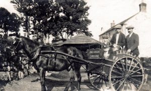 Milk man at a Pendray Farm
Menadarva is a beautiful spot, near the north coast and although only some three miles from Camborne, quite remote and unknown to many in the area – particularly those who have come into the area from outside. It is tucked into the south facing slope of a steep valley and is one of those places where spring comes early, even in Cornwall. Buildings in the farm yard here show quite clear evidence of Tudor architecture and may be from the earlier farm-house than the one that stands there now. Here is what Professor Charles Thomas has to say about the location in “Christian Antiquities of Camborne”. Although out of print, this book can be found in second hand book shops from time to time and is a must for the serious student of the Camborne area. He also mentions the early form of the name that refers to an early Celtic saint, Derwa and this area, close to Kehelland clearly features in the extant “life” of St Gwinear who purportedly landed on the coast near Gwithian.
“The present farmhouse of Menadarva, situated in a sheltered and wooded part of the Red River valley, and beautifully maintained, still exhibits many traces of the large stone house built by a branch of the Arundell family in the 16th century. Menadarva passed to the Bassets of Tehidy in the 18th century and although not a manor, has always been known as a barton.
The original holding here, farming a large south-facing area on the side of the valley beyond the house, gave its name to the family of Mertherderwa, who attained some prominence. Dr Reginald Mertherederwa, who was in holy orders, became the principal of Bull Hall, Oxford, subsequently merged into Corpus Christi College. (It was he who left a bequest for the erection of crosses along the churchway, running close to the family home) In 1509, Nicholas de Mertherderwa is mentioned in a Valuation of lands in the hundred of Penwith, but the property eventually passed through an heiress to the Bevills of Gwarnack and thence by another marriage to the Arundells.
The older place name of Mertherderwa is mentioned in 1285 and again as late as 1509, after which it becomes Menadarva (1600 and 1790). The older name implies a chapel of pre-Norman origin which contained the shrine and relics of Saint Derwa – a chapel, moreover, sufficiently well-known to give its name to a secular holding. The first mention of such a chapel occurs in Bishop Lacey’s Registrum Commune for 12th August 1429, recording a licence for divine worship by suitable priests “in capella sanctarum Ye et Derwe
virginum” in the parish of Camborne.”
Kehelland, like most other parts of Cornwall, has its mining past – certainly not significant enough to account for all the miners listed in successive census returns and not producing significant amounts of copper or tin as it was too far from the source of mineralisation and different minerals crystallised here. The once open, and unenclosed, area of Treswithian Downs contains many small lodes, some of which had been sampled in the 18th century by local miners. In 1862 a shaft was sunk on one of those lodes with the mine becoming known as Wheal Violet Seton. In 1878 Wheal Johnny was started some way to the west of Wheal Violet and took in that earlier working. The waste dumps of the mine are still evident in the fields east of Kehelland farm and over fifty years ago were the scene of a tragedy when a young man, out at night, thinking he was jumping over a hedge, went down the unfenced shaft to his death.
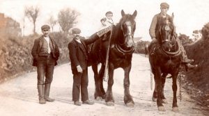 Going home from work at Kehelland between the wars
In 1882 there were three shafts on the mine with the deepest going to 75 fathoms (for those too young to know, a fathom is 6 feet – just under 2 metres and was a nautical measurement, probably used because the people who made ropes for ships also supplied the mining industry). At that time there were three steam pumping engines on the mine and two others for crushing and winding.
The mine produced copper and lead ore containing silver and by 1887 the mine had produced 1,270 tons of copper ore and the main shaft was down to 90 fathoms. In spite of this the mine probably never repaid the investment in it and it was a small concern in terms of Cornish mines. It eventually reached a depth of 100 fathoms but the ore was of a poor quality and the mine eventually closed. The main 70 inch steam pumping engine remained on the mine until it was purchased, in a rusty state, for the re-opening of Wheal Peevor, near Scorrier – the three engine house of which can clearly be seen from the A30 just past the Avers junction.
There is an interesting footnote to Wheal Johnny. A pumping engine consists of a simple device whereby a piston in the engine-house is pushed up and down by steam power to work a beam, half in and half out of the engine house. Steam pushes the piston up and raises the indoor end of a metal beam, pivoted at the centre, and the other end, connected to the long wooden rods going down the whole depth of the shaft to work the pumps, goes down. This repetitive motion works the pumps and keeps the mine clear of water. When the mine was abandoned the main pumping engine was disconnected from the wooden rods that it pulled up and down in the shaft to work the pumps. One length of the wooden pump rod was left connected to the outside end of the beam to maintain equilibrium and ensure the piston didn’t crash back down into the steam cylinder, damaging it. However, the length of pump rod left connected, lost or gained weight according to the weather and the beam was often seen to appear to work in spite of being derelict. Locals would say “Wheal Johnny’s made a stroke again”. Because of this regular movement the engine was in reasonable condition when it was sold to Wheal Peevor in 1911.
There was another industrial undertaking of note near Kehelland, in the hamlet of Roseworthy – the Roseworthy Hammer Mill which is, strictly speaking, part of the village’s area of influence as Kehelland men, including the late Edwin Phillips, worked there at one time. The most influential family there were the Goodman family, also stalwarts of Roseworthy Chapel and whose descendants still live locally. It made agricultural tools and specialised in the Cornish shovel which is still the tool of choice for us Cornish today. It was very similar, though on a far grander scale, to the Finches Foundry operated by the National Trust in Sticklepath, Devon.
 The Hammer Mill ponds at Roseworthy
There were also some other relatively small mining ventures very close to the village so the houses in the village clearly served a variety of purposes. The small terrace in the centre of Kehelland was clearly built to house workers and it seems more likely they were employed in an industrial setting rather than an agricultural one as many farms were typical of those in a Celtic area, forming small communities in themselves with housing within the curtilage of the farm for workers. So here is a community in a rural area but close enough, historically, to industrial settings to have that purpose as well. Socially, the time we know most about is the later nineteenth and twentieth centuries when that mining population was greatly diminished and the mines eventually disappeared as a source of employment. In that time period it became both a largely agricultural community and a dormitory settlement for those who worked in the nearby town. Pleasures in that period in the mid twentieth century when change gradually came were simple – the chapel still held sway as the focus of social life – the village had a thriving Institute, a cricket team and the people came together – carnivals and tea treats in summer and harvest suppers in the barn of one of the farms – a social cohesion the modern community is making efforts to re-create.
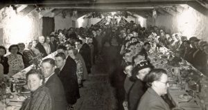 Harvest supper in a farm barn around 1950
It is now almost exclusively a dormitory settlement with people travelling to work outside the area but there are still a few families in the locality who have been here for generations and the nature of a community, past and present, is made by the people who live there. We can identify names and occupations from census lists but other records give a more substantial picture of who these people really were. Without a doubt – and almost certainly linked to the number of miners living locally – the Methodist Church held sway in the village and its environs for many years. There had been house meetings prior to the building of the first chapel in 1830 and as the nineteenth and early twentieth century passed, its influence increased. A new Wesleyan Chapel replaced the 1830 building and another chapel – “Higher Chapel” – was built for the United Methodist Free Church, reflecting the curious kind of class distinction evident in the Methodist Church, certainly in Cornwall. The actual membership of the Wesleyan Chapel (the present chapel) was regularly over 150 in the Victorian period but many of the names listed as officials disappear as men and their families were forced to seek their fortunes overseas as the mines closed.
Endnotes:
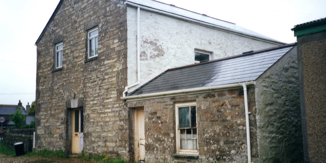
The photograph at the top of this article is Kehelland’s first chapel built c.1830 and now used as the village hall
 David Oates is a Cornish bard who has published a history of Troon, entitled “Echoes of an Age”, a guide to Godrevy and Gwithian, “Walk the hidden ways” and a slim volume of his own verse, “Poems from the far west”. His unpublished work includes a reflection on a Cornish childhood, “What time do they close the gates, Mister?” and a fictionalised story for young people based on the extant life of St Gwinear, with the working title, “The son of a king”. David is working on another guide in the “Walk the hidden ways” series, entitled “Hard Rock country”.
David is a tenor singer with the well-known group, Proper Job based in mid- Cornwall and has collaborated with Portreath musician, Alice Allsworth, to write the lyrics for a number of songs about Cornwall and the Cornish.
As soon as I see “county” I stop reading. Sorry. It alienates an entire section of the Cornish community, so while you can use the word, you do so knowing you are switching off a swathe of Cornish people.
I think that you could be missing a lot.
Just ordered a copy of the book