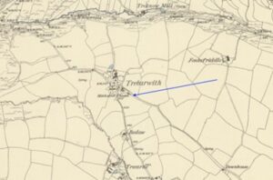
St Ives Wesleyan Chapel, Chapel Street, Lower Stennack, St Ives

Map of St Ives dated 1908   St Ives Wesleyan Chapel is often referred to as ‘The Mother Church of Cornish Methodism’   Compiled by Val Thomas. St Ives Old Cornwall. With the help of many reference books (particularly ‘St Ives Heritage’ Lena and Donald Bray), newspaper reports, St Ives Museum and Brian and Margaret…Continue Reading “St Ives Wesleyan Chapel, Chapel Street, Lower Stennack, St Ives”

Mapping Methodism – St Marys, Isles of Scilly, Wesleyan Chapel

Map: https://maps.nls.uk/geo/explore/side-by-side/#zoom=10.4&lat=52.44811&lon=-3.07812&layers=6&right=ESRIWorld This profile of St Mary’s Wesleyan Chapel has been compiled by Jo Lewis and Tony Mansell Located on the southern side of Garrison Road in Hugh Town, St Mary’s. 1742: John Wesley first visited the Islands (some references 1743) 1788: A society was formed.   1790 St Mary’s, Isles of Scilly Wesleyan Chapel…Continue Reading “Mapping Methodism – St Marys, Isles of Scilly, Wesleyan Chapel”

Mapping Methodism – St Marys Isles of Scilly Bible Christian Chapels

Map: https://maps.nls.uk/geo/explore/side-by-side/#zoom=10.4&lat=52.44811&lon=-3.07812&layers=6&right=ESRIWorld This profile of St Mary’s Bible Christian Chapel has been compiled by Jo Lewis and Tony Mansell The Bible Christian missionaries arrived in the islands in the 1820s and began preaching from the Bishop and Wolf Inn. These missionaries may have included Mary Ann Wherry one of the early female itinerant preachers of the…Continue Reading “Mapping Methodism – St Marys Isles of Scilly Bible Christian Chapels”

Mapping Methodism – Old Town Isles of Scilly Wesleyan Methodist Chapel

Map: https://maps.nls.uk/geo/explore/side-by-side/#zoom=10.4&lat=52.44811&lon=-3.07812&layers=6&right=ESRIWorld   This profile of Old Town Wesleyan Chapel has been compiled by Jo Lewis and Tony Mansell. Methodism on the Scilly Isles really got started in 1788 following a 1742 visit by John Wesley with the first chapel in Hugh Town. It is thought that Jospeh Sutcliffe, a WM itinerant, born at Baildon, Yorks…Continue Reading “Mapping Methodism – Old Town Isles of Scilly Wesleyan Methodist Chapel”

Mapping Methodism – Holy Vale (Maypole) Isles of Scilly Wesleyan Chapel, Isles of Scilly

Map: https://maps.nls.uk/geo/explore/side-by-side/#zoom=10.4&lat=52.44811&lon=-3.07812&layers=6&right=ESRIWorld This profile of Holy Vale (Maypole) Wesleyan Chapel has been compiled by Jo Lewis and Tony Mansell.   1815 Chapel Located near the centre of the island. 1815: Built as Holy Vale (Maypole) Wesleyan Methodist Chapel. Possibly the same meeting house referred to by Jeffrey in 1914 in which case it was clearly…Continue Reading “Mapping Methodism – Holy Vale (Maypole) Isles of Scilly Wesleyan Chapel, Isles of Scilly”

Mapping Methodism – Bryher Non-Conformist Chapel, Isles of Scilly

Map: https://maps.nls.uk/geo/explore/side-by-side/#zoom=10.4&lat=52.44811&lon=-3.07812&layers=6&right=ESRIWorld This profile of Bryher Non-Conformist Chapel has been compiled by Jo Lewis and Tony Mansell. Circa 1830-1843: There are records of a short-lived Baptist chapel on Bryher. The Baptist Itinerant Aid Society established Scilly as their first missionary station with chapels on all the inhabited islands including Bryher. Augustus Smith, ‘Lord Proprietor’ of…Continue Reading “Mapping Methodism – Bryher Non-Conformist Chapel, Isles of Scilly”