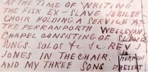
Old Bridge – a poem by Bert Biscoe

  Stand here by the Sunday School, Beside the Scholars’ House, Where rubber plant and yellow hammer And pigeon speak in tongues. The river brings cold clay, Washed away, washed away, And careless ploughs rubbing tynes Like silent crickets in tasteless hay Mock the ornamental scythe Crucified in converted barns –   Take a moment…Continue Reading “Old Bridge – a poem by Bert Biscoe”

The Demise of the S S Belem

 Cornwall’s coast is littered with maritime casualties and in this article Audrey Aylmer (Cares Enesow) of Bude Stratton & District Old Cornwall Society brings us its story of one of these, the Portuguese steamship Belem which was wrecked at Menachurch Point, Northcott Mouth, near Bude.       The SS Belem had been launched in 1890…Continue Reading “The Demise of the S S Belem”

The Silverwell Murder

Locations derived from the 1840s Tithe map and thought to be the same in 1851. There seems to be more than one possibilities for Butt Lane.   I was initially drawn to this case because Silverwell was my home for many years, it was where I was raised and where I spent so many years…Continue Reading “The Silverwell Murder”

Mapping Methodism – Quintrell Downs Bible Christian

Map: https://maps.nls.uk/geo/explore/side-by-side/#zoom=15.6&lat=50.40247&lon=-5.02722&layers=6&right=ESRIWorld   This profile of Quintrell Downs Bible Christian Chapel was compiled by Jo Lewis and Tony Mansell. Heritage Gateway: A Bible Christian chapel is recorded at this location on the 1st and 2nd Edition 1:2500 c1880 and c1907 OS maps and a building in the same footprint is recorded on the modern OS…Continue Reading “Mapping Methodism – Quintrell Downs Bible Christian”

Mapping Methodism – Sancreed Non-Conformist Chapel

Sancreed Non-Conformist Chapel has been profiled by Jo Lewis and Tony Mansell   Little has been found about this chapel. Non-Conformist Chapel (19th century – 1801 AD to 1900 AD) (HER) Heritage Gateway notes a post mediaeval chapel north of the Sancreed to Grumbla Road. Methodist chapel, now converted to house. To be inspected. There…Continue Reading “Mapping Methodism – Sancreed Non-Conformist Chapel”

Mapping Methodism – Gwinear Wesleyan Chapel

Map: https://maps.nls.uk/geo/explore/side-by-side/#zoom=15.0&lat=50.18785&lon=-5.35617&layers=6&right=ESRIWorld   This profile of Gwinear Wesleyan Chapel was compiled by Jo Lewis.   Approaching Gwinear from the East, the Wesleyan chapel was south of the road, set down a short track in a field. There is still a gap in the wall at this point, just before the houses start on the right but no…Continue Reading “Mapping Methodism – Gwinear Wesleyan Chapel”