Map: (https://maps.nls.uk/geo/explore/side-by-side/#zoom=16.0&lat=50.18276&lon=-5.39698&layers=257&right=ESRIWorld) This profile of Wheal Alfred Wesleyan Chapel has been compiled by Jo Lewis. Wheal Alfred Chapel lies south of Hayle but is best accessed by taking the Wheal Alfred Road from Ventonleague It was built circa 1815 for the local mining community – the hamlet itself was named for the local…Continue Reading “Mapping Methodism – Wheal Alfred Wesleyan Chapel”
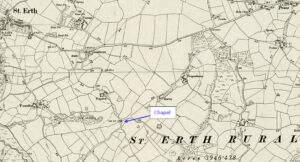
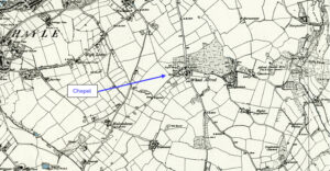
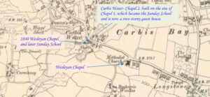
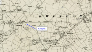
Map: https://maps.nls.uk/geo/explore/side-by-side/#zoom=14.9&lat=50.18067&lon=-5.34009&layers=6&right=ESRIWorld This profile of Hallancoose Nonconformist Chapel has been compiled by Jo Lewis. Heritage Gateway: A Wesleyan Methodist chapel is recorded on the 1st and 2nd Editions of the 1:2500 1880 and 1907 OS Maps. The remains of part of the chapel are shown in the road verge on the modern Mastermap….Continue Reading “Mapping Methodism – Hallancoose Wesleyan Chapel”
This impressive publication brings together the work of a team of researchers who cover the stories of women in relation to areas like maritime communities, banking, eighteenth century politics, First World War, landed estates and song. Published by Cornish Story Copies are available – £10 (plus postage) from the Institute – to order please…Continue Reading “Cornish Herstory edited by Dr Lesley Trotter of the Institute of Cornish Studies.”
Carbis Bay lies 1 mile (1.6 km) southeast of St Ives on the western coast of St Ives Bay. This profile of Carbis Bay Wesleyan Chapel has been compiled by Val Thomas of St Ives Old Cornwall Society. This area of what we now know as Carbis Bay used to be referred to as Uny,…Continue Reading ” Mapping Methodism -Carbis Water Wesleyan / Carbis Bay Wesleyan”
While clearing a ditch in that magical upland of West Penwith, just below the great hill-fort of Chûn, a farmer gradually revealed a relic from the distant past – a well with lintels of moorstone. Its age is uncertain, its magic undeniable From sunlit morn of dusty day Down steps worn smooth By countless…Continue Reading “Bosullow Well, a poem by David Oates”
Article written by Val Thomas, St Ives Old Cornwall. Bedford Road was built in 1899 on land originally owned by Edward Hain of The Terrace, then Treloyhan. He also owned the Manor House opposite the chapel which was in an area then called Green Court. This building had originally been owned by the…Continue Reading “Mapping Methodism – Bedford Road Methodist New Connexion/Wesleyan Church, St Ives.”


