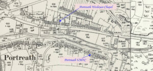
Sancreed Non-Conformist Chapel has been profiled by Jo Lewis and Tony Mansell Little has been found about this chapel. Non-Conformist Chapel (19th century – 1801 AD to 1900 AD) (HER) Heritage Gateway notes a post mediaeval chapel north of the Sancreed to Grumbla Road. Methodist chapel, now converted to house. To be inspected. There…Continue Reading “Mapping Methodism – Sancreed Non-Conformist Chapel”
Map: https://maps.nls.uk/geo/explore/side-by-side/#zoom=15.0&lat=50.18785&lon=-5.35617&layers=6&right=ESRIWorld This profile of Gwinear Wesleyan Chapel was compiled by Jo Lewis. Approaching Gwinear from the East, the Wesleyan chapel was south of the road, set down a short track in a field. There is still a gap in the wall at this point, just before the houses start on the right but no…Continue Reading “Mapping Methodism – Gwinear Wesleyan Chapel”
Map: https://maps.nls.uk/geo/explore/side-by-side/#zoom=15.0&lat=50.16118&lon=-5.41344&layers=6&right=ESRIWorld This profile of Porthcollum Bible Christian Chapel was compiled by Jo Lewis. Porthcollum Chapel lies south east of St Erth. Follow the Porthcollum Lane from St Erth Hill for some distance and the Chapel was at the junction with Countess Bridge Lane. Heritage Gateway: The Bible Christian magazine of 1851 recorded…Continue Reading “Mapping Methodism – Porthcollum Bible Christian Chapel”
Map: (https://maps.nls.uk/geo/explore/side-by-side/#zoom=16.0&lat=50.18276&lon=-5.39698&layers=257&right=ESRIWorld) This profile of Wheal Alfred Wesleyan Chapel has been compiled by Jo Lewis. Wheal Alfred Chapel lies south of Hayle but is best accessed by taking the Wheal Alfred Road from Ventonleague It was built circa 1815 for the local mining community – the hamlet itself was named for the local…Continue Reading “Mapping Methodism – Wheal Alfred Wesleyan Chapel”
Map: https://maps.nls.uk/geo/explore/side-by-side/#zoom=14.9&lat=50.18067&lon=-5.34009&layers=6&right=ESRIWorld This profile of Hallancoose Nonconformist Chapel has been compiled by Jo Lewis. Heritage Gateway: A Wesleyan Methodist chapel is recorded on the 1st and 2nd Editions of the 1:2500 1880 and 1907 OS Maps. The remains of part of the chapel are shown in the road verge on the modern Mastermap….Continue Reading “Mapping Methodism – Hallancoose Wesleyan Chapel”
This impressive publication brings together the work of a team of researchers who cover the stories of women in relation to areas like maritime communities, banking, eighteenth century politics, First World War, landed estates and song. Published by Cornish Story Copies are available – £10 (plus postage) from the Institute – to order please…Continue Reading “Cornish Herstory edited by Dr Lesley Trotter of the Institute of Cornish Studies.”


