
An Interview with Ann Preston-Jones
Bolster Bank at St Agnes is an important archaeological feature but it has long been the subject of speculation about its purpose. Questions like ‘why,’ ‘when,’ and ‘by whom,’ may never be answered with any certainty, but here, Ann Preston-Jones has revealed what we do know about it through a question-and-answer session.
Our thanks go to Ann for responding to our questions which we hope will increase awareness and share the knowledge of this once substantial creation.
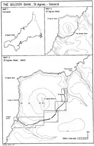
Maps from the Cornish Archaeology report courtesy of Nick Johnson and the Cornish Archaeology editor
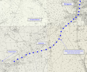
The line of Bolster Bank as indicated on various maps and here denoted by blue dots
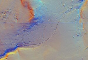
Digital terrain model of the Bolster Bank, based on Environment Agency data for SW74NW and SW75SW, © Environment Agency 2022.
It’s referred to as Bolster Bank but is that just a fanciful title related to the St Agnes Giant?
No! In fact, the name is from an isolated section of the bank at Bolster Farm. The name of Bolster Farm, which is first recorded in medieval times, is derived from two Cornish words: both, meaning ‘hump’ and lester, meaning ‘boat’. Together they mean ‘boat-shaped hump’ presumably referring to an upturned boat. The name of this section has given its name to the bank as a whole and then to the Giant, perhaps because of the bank’s monumental size.
Remarkably, this isolated section of the bank, referred to in the medieval name, still survives as a boat-shaped earthwork to this day.
Perhaps surprisingly, the name ‘Bolster Bank’ seems to be a relatively modern usage. Thomas Tonkin, who lived at Trevaunance and wrote a history of St Agnes, referred to it in the early 18th century as the ‘Gorres’ – a word derived from the Cornish guriz, a ‘girdle’, because of the way the bank wraps around the foot of the Beacon. Dr William Borlase, the famous Cornish antiquarian, said Tis called the Kledh, which in Cornish signifies the Trench, or Foss, and by the vulgar said to be the work of a giant called Bolster. There is a reference to the Bolster entrenchment at St Agnes in the late 19th century but the term ‘Bolster Bank’ first appears (as far as I know) in the second half of the 20th century.
With a ditch on the outside of a bank it sounds like a defensive structure. Is that how you see it?
That is one way of looking at it. Iron Age hillforts like Castle an Dinas also have deep defensive ditches on the outer face of their high banks. People within the bank could have stood on it and rained down arrows on any attackers struggling to get into the ditch and up the steep face of the bank whereas the other way round would not have worked from a defensive point of view.
The Bolster Bank may also have been intended as a show of the strength and importance of the people commanding the interior or signified the approach to a special place.
Some estimates are that the ditch was about 12 feet deep and the bank about 20 feet high. How were those measurements arrived at?
The bank varies in height and form along its length. At the two ends, where it hugs the steep-sided valleys, it is scarcely visible nowadays and no more than a notch cut to increase the steepness of the slope. It rises to its greatest height in the central section, between Goonvrea Road and a house called Firsdene, just before the road turns off to Chapel Porth. In the central section, at Goonvrea Farm, the bank now stands to an impressive height of 3.4m and the ditch to a maximum depth of 0.7m. The first person to provide us with measurements of the bank was Dr William Borlase; I don’t know how he arrived at them but he may have simply estimated, used some sort of measure or simply paced it out.
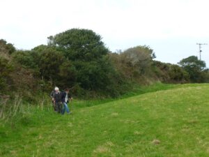
The Bank and Ditch (Photo: Peter Rose 18th October 2015)
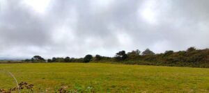
The Bank (Photo: Ann Preston-Jones 14th August 2026)
Do you think it could have been constructed to protect valuable mineral deposits or was it a safe area for people and cattle under attack?
That is a very good question. What exactly was being defended or protected within the area that the Bolster defines? As you know, the Bolster is very long; we archaeologists refer to it as a linear earthwork. It runs from Porth Chapel Coombe to Trevaunance Coombe and as such encloses the Beacon but also the tin mines around the Beacon, of which Polberro was the richest and earliest. Its purpose could well have been to defend this important area. A few Roman coins have been found in the area and although they don’t prove that mining was taking place in the Roman period, their presence may be suggestive of early exploitation of the ores around the Beacon.
Because most of the area within the Bolster would once have been heathland, used for rough grazing only, I am not sure that the Bolster’s purpose was to corral cattle. Another view of similar linear earthworks elsewhere is that they were territorial boundaries – although the enclosed area would be an unusual and small political territory.
A final suggestion for the function of the Bolster is that it defined a special, perhaps sacred, space focussed on the Beacon. This suggestion was made by my colleagues Graeme Kirkham and Adam Sharpe (see below for a full reference to their report). They consider that it is more likely to have been of ceremonial or ritual significance than a military or political site. The prominence of the Beacon in the surrounding landscape, the presence of Bronze Age cairns or barrows on top of the hill, the very unusual promontory fort or cliff castle on Tubby’s Head, plus the later legends associated with Giant Bolster and St Agnes may all point to the Bolster being of importance in enclosing the Beacon hill, known in Cornish as Breannick.
It would have taken a considerable workforce to construct it. Do you think that points to a single organising body like the Romans?
The overall planning and scale of the Bolster certainly suggests that its creation was a strategic concept. A local person or group of some importance, able to command considerable man-power, must have co-ordinated the construction. But we don’t know for sure that it was a Cornish Hadrian’s Wall, built by the Romans. We don’t actually know when the bank was built. But if you think that it was built to define the rich mineral wealth of the area, then they may well have had the necessary power and resource.
But it’s shown as a Roman Dyke on various old maps – on what was that conclusion based?
The great Dr Borlase, whom I mentioned above, and before him Thomas Tonkin, believed the Bolster to be Roman. At the time, they thought that no other people would have had the ability to plan and construct such a massive monument. The Ordnance Survey and other map makers would have followed the lead of these well-known antiquarians.
Thoughts on when it was constructed seem to range from the Iron Age to early Medieval or even later. Have you any thoughts on that?
Well …. the jury is out. Suggestions range from the Iron Age to the early Medieval period. Iron Age hillforts sometimes have long outworks; and up-country such banks are seen as Iron Age territorial boundaries. Roman is also possible though less likely. There is now more evidence of Roman activity in Cornwall than there was a few decades ago and the Romans are likely to have been in Cornwall to exploit its rich mineral wealth. However, the bank has also been compared to Offa’s Dyke, built in the 8th century by the Anglo-Saxon king Offa to protect his kingdom of Mercia from attack by the Welsh.
Apart from a few Roman coins, there seems to be little evidence of its age so do you think that we will ever be able to date it?
Of course, the Roman coins demonstrate a significant interest in the area but they do not actually date the Bolster.
I would love to know how old the Bolster Bank is! But it is likely to be difficult to date. Dating would require excavation of a section across the bank and ditch and because the main part of the earthwork is legally protected as a Scheduled Monument, it would be essential to get permission from the Department of Culture, Media and Sport. The hope would be that the excavation might find charcoal, which can be Radio-Carbon dated, although the chances of finding charcoal in this type of earthwork are probably very slight. However, there is now a scientific technique known as Optically Stimulated Luminescence that might work. This depends on excavating a trench and then finding the ancient, pre-construction land surface – a buried soil – under the bank. Any quartz in this can be dated by the last time it saw the light of day. In Cornwall we have had remarkable OSL results from King Arthur’s Hall on Bodmin Moor.
Is the Bolster Bank unique, or are there any other earthworks like the Bolster anywhere else in Cornwall?
There are two other certain examples, both of which define or protect very different areas. The Giant’s Hedge runs from Lerryn to Looe in south-east Cornwall, cutting off a very large area of rich farmland between the rivers Fowey and Looe. The other is the Giant’s Grave, close to the A30 at Crowlas in West Cornwall. This one is very intriguing. Only a short length survives but it has been suggested that when constructed it may have defined the entire peninsula of West Penwith: but we really can’t be sure. Further comparison has been made with the Dodman promontory fort in south Cornwall. Although it encloses a smaller area, the Dodman’s long and high ramparts define a very prominent headland within which there are two Bronze Age barrows. Intriguingly, the Dodman and the top of the Beacon are actually intervisible and both were primary triangulation points for the early Ordnance Survey!
Where can I find out more information about the Bolster Bank?
There is a very useful article by the former county archaeologist Nicholas Johnson in the journal Cornish Archaeology, volume 19 (1980), pp 77-88.
A report written for the National Trust also has some exceptionally interesting discussion. It is by Adam Sharpe and Graeme Kirkham of Cornwall Archaeological Unit, St Agnes Beacon, Tubby’s Head, Wheal Coates, Chapel Combe and Charlotte Moor, St Agnes, Cornwall Archaeological and ecological assessment for the National Trust and is available on-line: St Agnes western properties report combined sections . See especially pages 34-7, 68 and 72-3.
Peter Rose and Andrew Langdon kindly read through drafts of this discussion; Pete reminded me of the National Trust report.
This article has been compiled from a virtual interview undertaken by Tony Mansell.
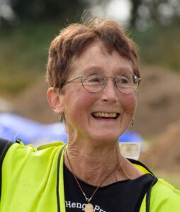
Ann Preston-Jones has been privileged to spend most of her life working as an archaeologist in Cornwall. She worked with both Cornwall Archaeological Unit and Historic England (formerly English Heritage) with a focus on the management, conservation and repair of Cornwall’s remarkable heritage, often working with local communities to ensure its protection. Side by side with this she has a strong interest in early medieval and later stone sculpture. Now retired, she continues to work as a volunteer with Cornwall Archaeological Society and Cornwall Heritage Trust, and Truro Diocese as one of their monuments’ advisors.
Ann is especially proud of the fact that she has just become a Granny!