Although we are unable to establish a firm date in which the following event took place, we can be sure that it was at a time when most people lived religious lives and almost everything they did between birth and death involved the local church or chapel. If however, there was one thing which stretched the boundaries of their faith, it was smuggling, or as we Cornish say, ‘The Fair Trade’.
Wikipeadia suggests that goods such as silks, tea, tobacco and brandy were more frequently smuggled into Cornwall than anywhere in England. It states that Cornish smugglers were not a violent breed, but they were very cunning. Smuggling became accepted and many took part in it and even some revenue men were quite amenable to the odd bribe.
Indeed, it was clearly a way of life when times were hard and many risks were taken to earn an extra shilling. Looking back we may prefer to believe that it was based on need rather than greed – a need which led people to the belief that the law was wrong and that depriving the state of its dues was acceptable.
Many Cornish coastal communities were involved in this lucrative trade and the stories of their exploits are portrayed in many books and films. Cornwall has a long coastline with countless coves and caves along its length. The rivers, too, provided an opportunity and one such place was the beach between St Just-in-Roseland and St Mawes.
Having been provided with the information, and the directions, by my cousin, Neville Paddy, I set out to try and find the location known as ‘Paddy’s Landing’. It was a reasonably fine day in May but there was rain in the air and I was aware that everyone I met on my journey was better prepared for that eventuality.
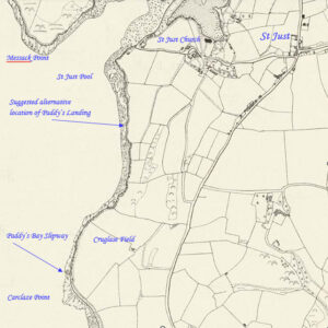
I parked my car just beyond St Just-in-Roseland Church and checked the Historic Environment Records’ map. Yes, there it was, Paddy’s Bay Slipway, out near Carclaze Point, a brave old jaunt away.
All the indicators, at this stage, suggested that Paddy’s Bay Slipway was the same place as Paddy’s Landing. I had no doubt about that. I made my way uphill and downhill along the bitmac road until I reached the river and the boatyard to my right. There, I turned left and continued until I was facing a large house which dampened my confidence a little but a quick check of Neville’s directions led me to a public footpath to the left of the house and into a field.

The footpath ran down towards the river and then along the bottom hedge, parallel with the beach. I was now heading south and from the map, I could see that my objective was about halfway to St Mawes.
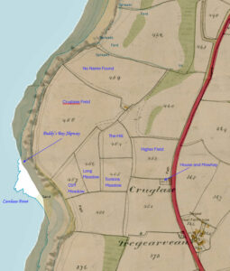
I traipsed along the well-worn path heading for Cruglase Field, or as Neville referred to it, “Paddy’s Furze Field.” This, and the others which I have named on the Tithe map, was farmed by William Paddy in the first half of the 19th century. This William was a direct ancestor of both Neville and me.
Neville’s notes stated, “There is only a barn where once the farmhouse stood. From there, Paddy’s Furze Field is below and beyond that is the beach and the entrance to a cave (Paddy’s Cave?), now collapsed, which ran from the shore up to Cruglase Farm. It is said that the tunnel had a dog-leg so that a boat could be out of view from the excise men.”
 The Tithe Map showing Cruglase Farm and the fields (named in blue) occupied by William Paddy in the early 1800s. The Historic Environment Records refers to the field-name Cruglase Field which, it states, contains the place-name element crug barrow.
Nev Meek, President of the Federation of Old Cornwall Societies, states that the word <krug> often indicates the location of a bronze age barrow. “In about 1500, Cruglaze/Cruglase was recorded as Cruklas, which gives us the original meaning <krug> mound or barrow and <glas> meaning green.”
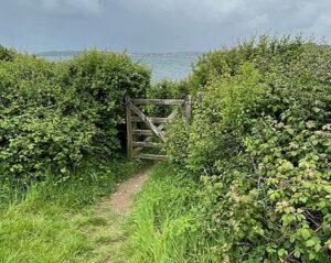
At the southern end of the footpath in Cruglase field, on the right, is a narrow gateway and this is what I had been seeking. It opened onto a short pathway down to the beach and there I found a built slipway or landing. Without doubt, this was Paddy’s Landing.
 The gateway from Cruglase Field to the beach.
 The granite slipway – Paddy’s Bay Slipway which we know as Paddy’s Landing.
I mentioned earlier that smuggling was a very common activity in Cornwall and many of us with a Cornish pedigree can recall stories of family members who were involved in this nefarious trade. One such man was a member of the Paddy line of my family. Unfortunately, we know little about him. His identity remains a mystery but he is embedded in our family history and I make no apology for perpetuating his story. Positively identifying him, and the period in which he lived, has become a passion of mine, and of cousin Neville who believes that he was a son of William Paddy the farmer at Cruglase Farm. We both have to admit to a sneaking desire to find that he was a direct ancestor of ours.
That his story is intriguing is without doubt: it needs no embellishment but perhaps a touch of conjecture may help us to imagine what may have happened in what was to be his final smuggling operation.
Picture the scene, if you will, of a still, moonlit night. The gentle strokes of oars guiding a little boat towards the beach near Carclaze Point. The crunch of bow on shingle was followed by a small group of men, either friends or family, stepping onto the beach and unloading their illicit cargo. Perhaps donkeys or mules were there waiting with muffled hooves to convey their ill-gotten gains to a safe hiding place.
Maybe there was a warning shout, perhaps not, but the certain sound of gunfire suddenly disturbed the still night and signalled the fact that the group had been discovered. We are left to wonder if there was a return of fire: perhaps causing the revenue men to remain at a distance.
Anyway, to return to the evidence. Well alright, the anecdotal evidence. The gang was disturbed in the act of smuggling and at least one shot was fired by the Revenue Officers and one of the smugglers lay dead. With that, a legend was born. That man was our unknown Paddy and in the quiet of the night, his colleagues buried him where he fell.
Since that fateful night, the location has been known as Paddy’s Landing but like so many other aspects of this account, we are uncertain if his body was eventually recovered and given a Christian burial.
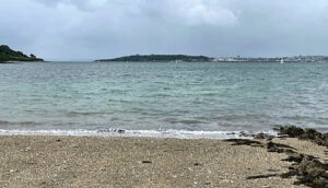
 The view from the beach with Pendennis Castle in the distance.
So, who are the prime candidates on whom we can dine out?
The farmer, William Paddy (baptised 1791) of Cruglase Farm was certainly ideally located to take advantage of any smuggling activities in this area. He died in 1842, having lived at Cruglase Farm for over 40 years but we have not been able to establish the cause of his death so could he have been our smuggler?
Another William Paddy, (baptised 1709), ran a pub in St Gerrans Churchtown to the north of the church, and this profession may suggest a motive for the landing of illicit brandy.
It could have been either of these or perhaps one of their offspring. There again, it could have been any of the rest of the Paddy clan who populated the Roseland. (Mr Powell, a local farmer, states that at one time, nearly a whole classroom at the village school was filled with children called Paddy).
But while William number one had the opportunity and William number two had the motive, we are a smuggler’s mile away from putting their names in the frame.
Now, you would think that an action such as this would make the newspapers – some sort of report which would give this story credibility, but nothing has been found – so far. Despite that, the story is compelling. The landing or slipway does exist with the Paddy name associated with it, and Neville Paddy and his brother, Fred, toured the area chatting to many people who have vague recollections of hearing the story. This includes a Mr Couch, whose family have farmed the area for many centuries. It was he who confirmed the existence of Paddy’s Landing which he has always understood to be connected with a smuggler by that name.
Having succeeded in my objective of finding the landing or slipway I turned and headed back across the fields. Yes, it had begun to rain! A lady saw me looking at my map and asked if I was lost. I said that I wasn’t, and that I was feeling quite pleased with myself as I had found what I was looking for. It turned out that she was local to that area and knew the story of Paddy’s Landing but, and it was a big but, her understanding was that the location was further north – in the field nearest St Just-in-Roseland (see first map). She also thought that the location shown on the Heritage Environment Records was known locally as Chynoweth’s Landing. She did admit that she may have confused the two locations but her suggestion was sufficient to put doubts in my mind so I headed off the examine her alternative location. There was a gate and a pathway down to the beach but there was no built slipway or landing.
I believe that the map is correct in showing Paddy’s Bay Slipway near Carglaze Point but whichever is the true location, it does not alter the account of the incident. Is itb all based on fact and will we ever fill in the details? Well. I don’t know but like so many Cornish events, if ‘tidn true then it oughta be!
Postscript by Stephen Miles:
“My family have farmed the land behinds Paddy’s Bay – we took over from Joe Teague in 1986 who farmed it from the 1920s. Joe told us the story of Paddy the smuggler. The fields Cliff Meadow, Tonkins and Higher Field according to Joe were called Lower, Middle and Upper Paddy’s. The landing nearer to St Just is Chenoweth’s landing – the Chenoweth’s farmed Stanton farm and they brought in lime using the beach.
Gruglase field name does make sense as there is a large mound in it, the name we know it by is the Great field.”
Footnotes:
- The Fair Trade was a term applied to the practice of smuggling.
- Furze is a wild bush with sharp thorns and small, yellow flowers – also called gorse. It was a cheap form of fuel used in Cornish stoves.
- Revenue Officers patrolled the coast to apprehend smugglers.
Acknowledgements:
Kim Cooper of Kresen Kernow with the Tithe Map.
Nev Meek of Portscatho.
Neville Paddy of Mount Hawke, my cousin.

Tony Mansell is the author of several books on aspects of Cornish history. In 2011 he was made a Bardh Kernow (Cornish Bard) for his writing and research, taking the name of Skrifer Istori. He has a wide interest in Cornish history, is a researcher with the Cornish National Music Archive and a sub-editor with Cornish Story.

My family have farmed the land behinds Paddy’s Bay We took over from Joe Teague in 1986 and he started farming in 1920s
Joe told us the story of Paddy the smuggler the fields Cliff meadow Tonkins and higher field according to Joe were called lower middle and upper Paddy’s.
The landing nearer to St Just is Chenoweth’s landing the Chenoweth’s farmed Stanton farm and they brought lime using the beach.
Gruglase field name does make sense as there is a large mound in it, the name we know it by is the Great field.
Thank you for this additional information, Stephen. I have added it to the article under your name.
Thank you Tony for this story, I enjoyed remembering parts re: told to me by my dad and Uncle Fred and Uncle Neville.
All best,
Kenwyn Paddy
Hi Kenwyn, hope all good with you. Yes, an intriguing story and one which has a lot of evidence but, unfortunately, some supposition. I’m sure it happened but it would be good to fill in the details. The search continues. Gwella (Best) Tony