
Mapping Methodism – Blowing House Primitive Methodist (Grenifer) Chapel
Categories Mapping Methodism, Projects1 Comment
Blowinghouse or Blowing House is an area to the east of Reduth Hospital, the old workhouse. This profile of Blowinghouse Primitive Wesleyan Chapel has been compiled by Jo Lewis and Tony Mansell.
In 1849 a Joel Blamey (a Bible Christian convert and once leader at the Blowinghouse / Grenifer Chapel…now lost) moved to Tuckingmill on the closure of Blowinghouse Chapel. (My Primitive Methodists)
The 1850 Chapel
A Primitive Methodist chapel is recorded on the 1st Edition 1:2500 1880 OS Map at this location in Blowinghouse. By 1907 there is no chapel shown on the 2nd Edition 1:2500 OS Map. (Cornwall Council Heritage Gateway)
There were weekly class meetings at Roscroggan, Tolvaddon Downs, Illogan Downs, Lower Melrose, Pool, Blowinghouse/Grenifer (in the valley behind us…and the base of the meeting house remains built next to the old stream works), Condurrow, Pengegon and Illogan Highway. (My Primitive Methodists)
The chapel location has been determined by reference to the Cornwall Council Heritage Gateway map.
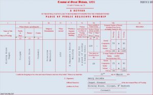 From this 1851 return we can deduce that a new chapel was built in 1850 which, presumably, replaced the one closed in 1849, when Joel Blamey transferred to Tuckingmill.
1850: Blowing House Primitive Methodist Chapel built. (1851 Place of Public Religious Worship Return)
1880 & 1888: Shown on maps. (old.maps.co.uk)
Closure date unknown.
1908: No longer shown on map. (old.maps.co.uk)
My ancestors, the Pearce family(ies), who were Wesleyan Methodists, lived in the cottages 50 yards or so from your Blowinghouse Primitive Methodist Chapel. They were in the cottages shown on your old map, at 10 O’clock’ish to the chapel. Not the ones with a northwest alignment, but the ones parallel to the south side of the Illogan Hoghway. (Wish I could paste a screenshot here!). The cottages are no longer there but I have some old photos of them (1900’s). My ancestors lived there in the 1800s, and then went to Namaqualand, Southern Africa in the 1870s.