
Mapping Methodism – Carlidnack Bible Christian Chapel
Categories Mapping Methodism, Projects1 Comment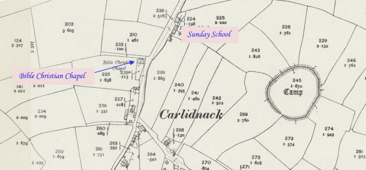
Carlidnack is a hamlet in the parish of Mawnan, 2.7 miles south-west of Falmouth on a road leading north-east from Mawnan Smith. This profile of Carlidnack Bible Christan Chapel has been compiled by Jo Lewis and Tony Mansell.
There are Sunday school records from 1888 so this may be the original date for both.
First indicated on 1907 maps as a Bible Christian chapel on the west side of the Carlidnack road through Carlidnack, at the junction with Chapel Town Close. The Sunday school is marked further north on the other side of the road and may have been the previous chapel, but this is, as yet, unconfirmed.
Built as a Bible Christian chapel. (SWChurches)
Indicated on 1907 old.maps.co.uk but not on 1879 or 1888.
1907: The Methodist New Connexion, Bible Christians and United Methodist Free Churches amalgamated to become the United Methodist Church.
1907: Became Carlidnack United Methodist Church. (SWChurches)
1932: The Wesleyan, Primitive Methodist and the United Methodist Church amalgamated to become the Methodist Church of Great Britain.
1932: Became Carlidnack Methodist Church. (SWChurches)
1940: Seating for 140. (David Easton, Methodist Minister and historian)
1910-1952: Minutes and accounts, Carlidnack Methodist Church, Mawnan. Church meeting minutes, 1910-1911; special account, 1910-1932; Trust minutes, 1931-1952. (Kresen Kernow MRF/121)
1954: Certificate of registration, Carlidnack Methodist Church, Mawnan. Certificate of registration as place of religious worship. (Kresen Kernow MRF/543)
1954: Certificate of registration, marriages, Carlidnack Methodist Church, Mawnan. (Kresen Kernow MRF/544)
1960: Plan, proposed additions, Carlidnack Methodist Church, Mawnan. Proposed schoolroom, kitchen and toilets. Size: 28×17 inches. (Kresen Kernow MRF/545)
1960: Plans, proposed schoolroom and kitchen, Carlidnack Methodist Church, Mawnan. Plan, elevation and sections. (Kresen Kernow MRF/130)
1960: Planning consent, proposed schoolroom, Carlidnack Methodist Church, Mawnan. Consent from local council. (Kresen Kernow MRF/131)
1960: Planning consent, proposed schoolroom, Carlidnack Methodist Church, Mawnan. Consent from local council. (Kresen Kernow MRF/132)
1961-1962: Vouchers, Carlidnack Methodist Church. Includes membership tickets for Alec Pascoe and Mrs Elvena Pascoe, 1962; correspondence relating to ownership of Sunday School premises and land. (Kresen Kernow MRF/656)
1966-1967: Correspondence, circuit assessments, Carlidnack Methodist Church. (Kresen Kernow MRF/661)
1968: Papers, acquisition of freehold, Carlidnack Methodist Church, Mawnan. (Kresen Kernow MRF/546)
1967: Closed. (David Easton, Methodist Minister and historian)
1968: Closed, (SWChurches)
1953-1968: Trust minutes, Carlidnack Methodist Church, Mawnan. (Kresen Kernow MRF/122)
Congregation joined Mawnan Smith Methodists. (David Easton, Methodist Minister and historian)
Chapel converted to dwelling. (David Easton, Methodist Minister and historian)
Planning for conversion was agreed in 1976 and the house has recently been extended (Foxglove Cottage)
Great stuff, enjoying this hugely.
Happy boyhood memories of both Mawnan chapel and also Carlidnack chapel.