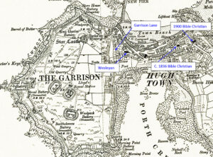
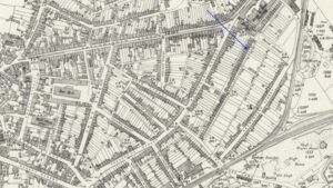
Mapping Methodism – St Marys Isles of Scilly Bible Christian Chapels

Map: https://maps.nls.uk/geo/explore/side-by-side/#zoom=10.4&lat=52.44811&lon=-3.07812&layers=6&right=ESRIWorld This profile of St Mary’s Bible Christian Chapel has been compiled by Jo Lewis and Tony Mansell The Bible Christian missionaries arrived in the islands in the 1820s and began preaching from the Bishop and Wolf Inn. These missionaries may have included Mary Ann Wherry one of the early female itinerant preachers of the…Continue Reading “Mapping Methodism – St Marys Isles of Scilly Bible Christian Chapels”

Mapping Methodism – Old Town Isles of Scilly Wesleyan Methodist Chapel

Map: https://maps.nls.uk/geo/explore/side-by-side/#zoom=10.4&lat=52.44811&lon=-3.07812&layers=6&right=ESRIWorld   This profile of Old Town Wesleyan Chapel has been compiled by Jo Lewis and Tony Mansell. Methodism on the Scilly Isles really got started in 1788 following a 1742 visit by John Wesley with the first chapel in Hugh Town. It is thought that Jospeh Sutcliffe, a WM itinerant, born at Baildon, Yorks…Continue Reading “Mapping Methodism – Old Town Isles of Scilly Wesleyan Methodist Chapel”

Mapping Methodism – Holy Vale (Maypole) Isles of Scilly Wesleyan Chapel, Isles of Scilly

Map: https://maps.nls.uk/geo/explore/side-by-side/#zoom=10.4&lat=52.44811&lon=-3.07812&layers=6&right=ESRIWorld This profile of Holy Vale (Maypole) Wesleyan Chapel has been compiled by Jo Lewis and Tony Mansell.   1815 Chapel Located near the centre of the island. 1815: Built as Holy Vale (Maypole) Wesleyan Methodist Chapel. Possibly the same meeting house referred to by Jeffrey in 1914 in which case it was clearly…Continue Reading “Mapping Methodism – Holy Vale (Maypole) Isles of Scilly Wesleyan Chapel, Isles of Scilly”

Mapping Methodism – Bryher Non-Conformist Chapel, Isles of Scilly

Map: https://maps.nls.uk/geo/explore/side-by-side/#zoom=10.4&lat=52.44811&lon=-3.07812&layers=6&right=ESRIWorld This profile of Bryher Non-Conformist Chapel has been compiled by Jo Lewis and Tony Mansell. Circa 1830-1843: There are records of a short-lived Baptist chapel on Bryher. The Baptist Itinerant Aid Society established Scilly as their first missionary station with chapels on all the inhabited islands including Bryher. Augustus Smith, ‘Lord Proprietor’ of…Continue Reading “Mapping Methodism – Bryher Non-Conformist Chapel, Isles of Scilly”

Mapping Methodism – St Agnes Bible Christian Chapel, Isles of Scilly 

Map: https://maps.nls.uk/geo/explore/side-by-side/#zoom=10.4&lat=52.44811&lon=-3.07812&layers=6&right=ESRIWorld This profile of St Agnes Bible Christian Chapel has been compiled by Jo Lewis and Tony Mansell. (Ann Cunningham) The Chapel is marked on OS maps (1888 and 1906) on the north side of Old Lane in the north of the Island (Lower Town). The Bible Christian missionaries arrived in the islands in the…Continue Reading “Mapping Methodism – St Agnes Bible Christian Chapel, Isles of Scilly “

Mapping Methodism – St Martins Isles of Scilly Bible Christian Chapel

Map: https://maps.nls.uk/geo/explore/side-by-side/#zoom=10.4&lat=52.44811&lon=-3.07812&layers=6&right=ESRIWorld This profile of St Martin’s Bible Christian Chapel has been compiled by Jo Lewis and Tony Mansell. (Ann Cunningham) The Bible Christian missionaries arrived in the islands in the 1820s and began preaching from the Bishop and Wolf Inn on St Marys. Founded circa1821 and the congregation are said to have built this…Continue Reading “Mapping Methodism – St Martins Isles of Scilly Bible Christian Chapel”