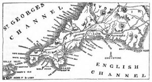
Mapping Methodism – Quintrell Downs Bible Christian

Map: https://maps.nls.uk/geo/explore/side-by-side/#zoom=15.6&lat=50.40247&lon=-5.02722&layers=6&right=ESRIWorld   This profile of Quintrell Downs Bible Christian Chapel was compiled by Jo Lewis and Tony Mansell. Heritage Gateway: A Bible Christian chapel is recorded at this location on the 1st and 2nd Edition 1:2500 c1880 and c1907 OS maps and a building in the same footprint is recorded on the modern OS…Continue Reading “Mapping Methodism – Quintrell Downs Bible Christian”

Mapping Methodism – Sancreed Non-Conformist Chapel

Sancreed Non-Conformist Chapel has been profiled by Jo Lewis and Tony Mansell   Little has been found about this chapel. Non-Conformist Chapel (19th century – 1801 AD to 1900 AD) (HER) Heritage Gateway notes a post mediaeval chapel north of the Sancreed to Grumbla Road. Methodist chapel, now converted to house. To be inspected. There…Continue Reading “Mapping Methodism – Sancreed Non-Conformist Chapel”

Mapping Methodism – Gwinear Wesleyan Chapel

Map: https://maps.nls.uk/geo/explore/side-by-side/#zoom=15.0&lat=50.18785&lon=-5.35617&layers=6&right=ESRIWorld   This profile of Gwinear Wesleyan Chapel was compiled by Jo Lewis.   Approaching Gwinear from the East, the Wesleyan chapel was south of the road, set down a short track in a field. There is still a gap in the wall at this point, just before the houses start on the right but no…Continue Reading “Mapping Methodism – Gwinear Wesleyan Chapel”