
In memory of Captain J S Harris By Thomas Roberts “A good name is rather to be chosen than great riches, and a loving favour rather than silver and gold.” Our good Captain Harris and friend is gone, To be with Christ his Lord; The fight is fought, the victory’s won, He’s gone to…Continue Reading “In memory of Captain J S Harris – a 19th century poem”
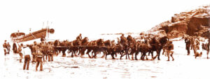
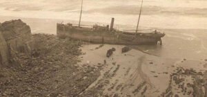
The wreck of the VIKING – March 1872 Harlyn Bay The Arab at Harlyn (Photo: courtesy Malc McCarthy) John Buckingham brings us a real-life sea drama involving the demise of the barque Viking, and the remarkable bravery of the men of the Albert Edward who went to her aid. Here, there is drama in the…Continue Reading “Courage Above and Beyond”

Stand here by the Sunday School, Beside the Scholars’ House, Where rubber plant and yellow hammer And pigeon speak in tongues. The river brings cold clay, Washed away, washed away, And careless ploughs rubbing tynes Like silent crickets in tasteless hay Mock the ornamental scythe Crucified in converted barns – Take a moment…Continue Reading “Old Bridge – a poem by Bert Biscoe”
Cornwall’s coast is littered with maritime casualties and in this article Audrey Aylmer (Cares Enesow) of Bude Stratton & District Old Cornwall Society brings us its story of one of these, the Portuguese steamship Belem which was wrecked at Menachurch Point, Northcott Mouth, near Bude. The SS Belem had been launched in 1890…Continue Reading “The Demise of the S S Belem”
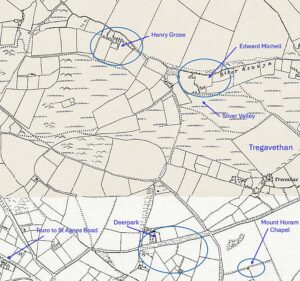
Locations derived from the 1840s Tithe map and thought to be the same in 1851. There seems to be more than one possibilities for Butt Lane. I was initially drawn to this case because Silverwell was my home for many years, it was where I was raised and where I spent so many years…Continue Reading “The Silverwell Murder”
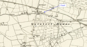
Map: https://maps.nls.uk/geo/explore/side-by-side/#zoom=15.6&lat=50.40247&lon=-5.02722&layers=6&right=ESRIWorld This profile of Quintrell Downs Bible Christian Chapel was compiled by Jo Lewis and Tony Mansell. Heritage Gateway: A Bible Christian chapel is recorded at this location on the 1st and 2nd Edition 1:2500 c1880 and c1907 OS maps and a building in the same footprint is recorded on the modern OS…Continue Reading “Mapping Methodism – Quintrell Downs Bible Christian”