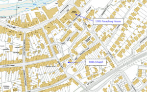
Mapping Methodism – Mountjoy / Mount Joy Wesleyan Chapel

Map: https://maps.nls.uk/geo/explore/side-by-side/#zoom=10.4&lat=52.44811&lon=-3.07812&layers=6&right=ESRIWorld   This profile of Mountjoy Wesleyan Chapel has been compiled by Jo Lewis and Tony Mansell. Located east of Quintrell Downs and south east of Colan – on the north side of the A392. Kresen Kernow documents: https://kresenkernow.org/SOAP/search/RelatedNameCode.keyword/CRO%7CUK%7C990/   First Mountjoy Wesleyan Chapel Located north of the A392, signposted Colan, and there is…Continue Reading “Mapping Methodism – Mountjoy / Mount Joy Wesleyan Chapel”

Mapping Methodism – Lane Wesleyan Chapel

 Map: https://maps.nls.uk/geo/explore/side-by-side/#zoom=15.3&lat=50.40478&lon=-5.06395&layers=6&right=ESRIWorld   This profile of Lane Wesleyan Chapel has been compiled by Jo Lewis and Tony Mansell.   Lane Wesleyan Chapel (Photo Jo Lewis) Located at the north-eastern corner of the A392 roundabout, where it meets the Treloggan Road connection to Newquay. This small chapel is a familiar landmark. Build date: 1879. 1879: New…Continue Reading “Mapping Methodism – Lane Wesleyan Chapel”

Mapping Methodism – Trelights Wesleyan Methodist Association Chapel

Map: https://maps.nls.uk/geo/explore/side-by-side/#zoom=17.4&lat=50.57839&lon=-4.84069&layers=6&right=ESRIWorld   This profile of Trelights Wesleyan Chapel has been compiled by Jo Lewis and Tony Mansell.   First Trelights Wesleyan Methodist Association Chapel Approaching the village from the north, the chapel is on the left before the centre of the village. Local history puts this chapel under Bible Christian History and continues to…Continue Reading “Mapping Methodism – Trelights Wesleyan Methodist Association Chapel”

Mapping Methodism – Trelights Bible Christian Chapel

Map: https://maps.nls.uk/geo/explore/side-by-side/#zoom=17.4&lat=50.57839&lon=-4.84069&layers=6&right=ESRIWorld   This profile of Trelights Bible Christian Chapel has been compiled by Jo Lewis.   Approaching from the north, travel round in a south east direction and the road swings back with a left straight on towards Furze Park (road). At this junction, the old chapel is on the left. The first Bible…Continue Reading “Mapping Methodism – Trelights Bible Christian Chapel”

Mapping Methodism – West Portholland Bible Christian Chapel

Map: https://maps.nls.uk/geo/explore/side-by-side/#zoom=10.4&lat=52.44811&lon=-3.07812&layers=6&right=ESRIWorld   This profile of West Portholland Bible Christian Chapel has been compiled by Jo Lewis and Tony Mansell.   The chapel overlooks the cove and its small harbour from the harbour’s western flank. This lovely stone building was erected in 1858 to replace the now-lost chapel built on an unstable cliff alongside the…Continue Reading “Mapping Methodism – West Portholland Bible Christian Chapel”

Mapping Methodism – East Portholland Wesleyan Chapel

Map: https://maps.nls.uk/geo/explore/side-by-side/#zoom=10.4&lat=52.44811&lon=-3.07812&layers=6&right=ESRIWorld This profile of East Portholland Wesleyan Chapel has been compiled by Jo Lewis and Tony Mansell. The chapel overlooks the cove from the west bank of the brook dividing east from west.   First East Portholland Wesleyan Chapel Heritage Gateway: Wesleyan chapel, later a Sunday school from when 1881 chapel built alongside, now…Continue Reading “Mapping Methodism – East Portholland Wesleyan Chapel”